You are here: Home > Network List > IU - Global Seismograph Network (GSN - IRIS/USGS) Stations List
> Station NWAO Narrogin, Australia > Earthquake Result Viewer
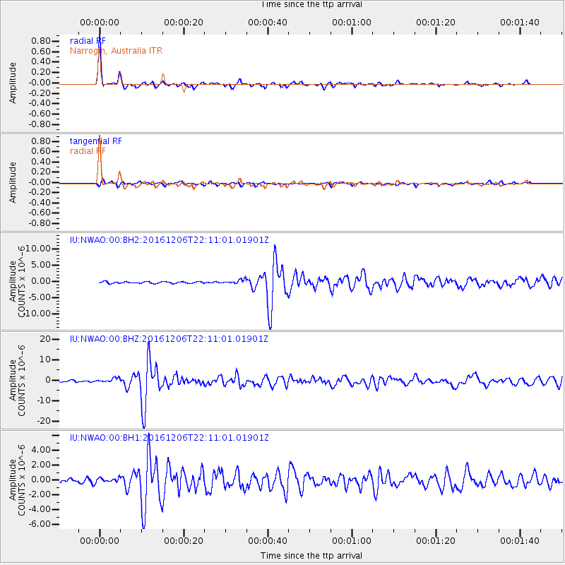
NWAO Narrogin, Australia - Earthquake Result Viewer
| Earthquake location: |
Northern Sumatra, Indonesia |
| Earthquake latitude/longitude: |
5.3/96.1 |
| Earthquake time(UTC): |
2016/12/06 (341) 22:03:32 GMT |
| Earthquake Depth: |
8.2 km |
| Earthquake Magnitude: |
6.5 Mww |
| Earthquake Catalog/Contributor: |
NEIC PDE/us |
|
| Network: |
IU Global Seismograph Network (GSN - IRIS/USGS) |
| Station: |
NWAO Narrogin, Australia |
| Lat/Lon: |
32.93 S/117.24 E |
| Elevation: |
380 m |
|
| Distance: |
43.0 deg |
| Az: |
153.588 deg |
| Baz: |
328.218 deg |
| Ray Param: |
0.07285607 |
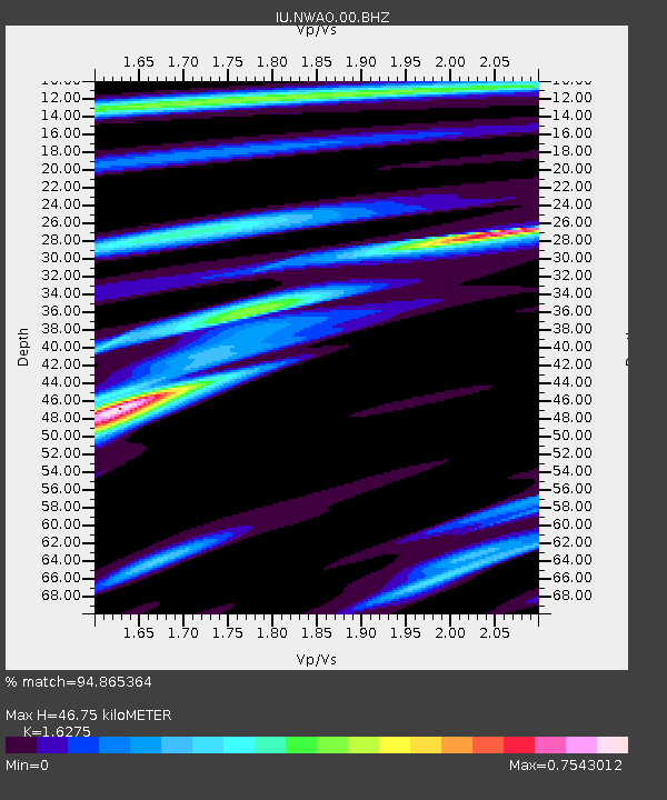
| Estimated Moho Depth: |
46.75 km |
| Estimated Crust Vp/Vs: |
1.63 |
| Assumed Crust Vp: |
6.419 km/s |
| Estimated Crust Vs: |
3.944 km/s |
| Estimated Crust Poisson's Ratio: |
0.20 |
|
| Radial Match: |
94.865364 % |
| Radial Bump: |
174 |
| Transverse Match: |
75.488464 % |
| Transverse Bump: |
390 |
| SOD ConfigId: |
1894071 |
| Insert Time: |
2016-12-20 22:05:04.010 +0000 |
| GWidth: |
2.5 |
| Max Bumps: |
400 |
| Tol: |
0.001 |
|
Signal To Noise
| Channel | StoN | STA | LTA |
| IU:NWAO:00:BHZ:20161206T22:11:01.01901Z | 2.890139 | 1.1044709E-6 | 3.8215148E-7 |
| IU:NWAO:00:BH1:20161206T22:11:01.01901Z | 1.5989556 | 2.9031867E-7 | 1.8156767E-7 |
| IU:NWAO:00:BH2:20161206T22:11:01.01901Z | 2.6560183 | 6.4326287E-7 | 2.4219068E-7 |
| Arrivals |
| Ps | 4.9 SECOND |
| PpPs | 18 SECOND |
| PsPs/PpSs | 23 SECOND |


