You are here: Home > Network List > TA - USArray Transportable Network (new EarthScope stations) Stations List
> Station N16K Nishlik Lake, AK, USA > Earthquake Result Viewer
N16K Nishlik Lake, AK, USA - Earthquake Result Viewer
| Earthquake location: |
Vanuatu Islands |
| Earthquake latitude/longitude: |
-15.5/167.5 |
| Earthquake time(UTC): |
2019/07/01 (182) 17:13:29 GMT |
| Earthquake Depth: |
100 km |
| Earthquake Magnitude: |
6.0 Mww |
| Earthquake Catalog/Contributor: |
NEIC PDE/us |
|
| Network: |
TA USArray Transportable Network (new EarthScope stations) |
| Station: |
N16K Nishlik Lake, AK, USA |
| Lat/Lon: |
60.47 N/158.77 W |
| Elevation: |
582 m |
|
| Distance: |
80.4 deg |
| Az: |
16.192 deg |
| Baz: |
212.878 deg |
| Ray Param: |
0.048099168 |
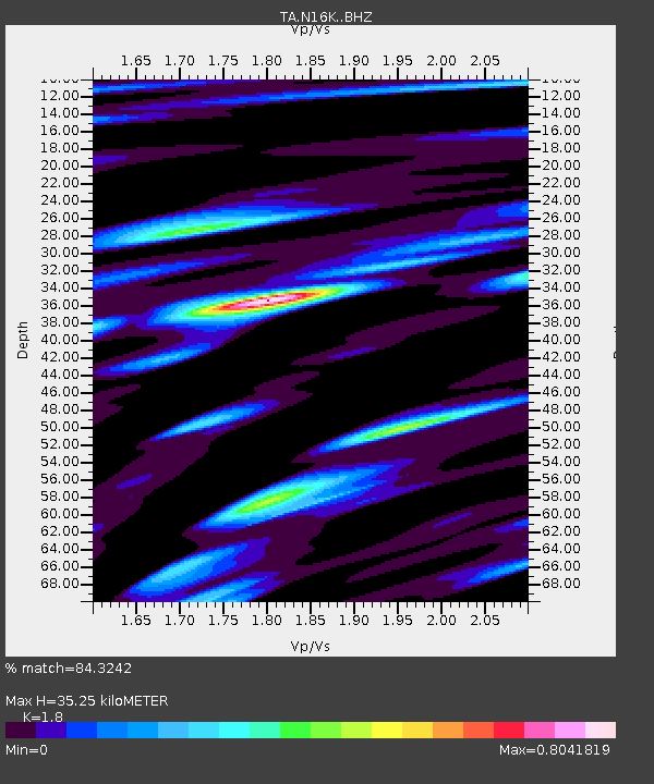
| Estimated Moho Depth: |
35.25 km |
| Estimated Crust Vp/Vs: |
1.80 |
| Assumed Crust Vp: |
6.276 km/s |
| Estimated Crust Vs: |
3.487 km/s |
| Estimated Crust Poisson's Ratio: |
0.28 |
|
| Radial Match: |
84.3242 % |
| Radial Bump: |
400 |
| Transverse Match: |
59.08478 % |
| Transverse Bump: |
400 |
| SOD ConfigId: |
18369291 |
| Insert Time: |
2019-07-15 17:20:35.884 +0000 |
| GWidth: |
2.5 |
| Max Bumps: |
400 |
| Tol: |
0.001 |
|

Signal To Noise
| Channel | StoN | STA | LTA |
| TA:N16K: :BHZ:20190701T17:24:58.624999Z | 10.424778 | 1.0070207E-6 | 9.659877E-8 |
| TA:N16K: :BHN:20190701T17:24:58.624999Z | 3.665218 | 3.4015855E-7 | 9.280718E-8 |
| TA:N16K: :BHE:20190701T17:24:58.624999Z | 2.9623275 | 2.2688644E-7 | 7.65906E-8 |
| Arrivals |
| Ps | 4.6 SECOND |
| PpPs | 15 SECOND |
| PsPs/PpSs | 20 SECOND |


