You are here: Home > Network List > TA - USArray Transportable Network (new EarthScope stations) Stations List
> Station O17K Koliganek, Bristol Bay, AK, USA > Earthquake Result Viewer
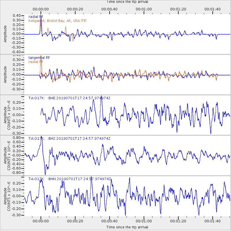
O17K Koliganek, Bristol Bay, AK, USA - Earthquake Result Viewer
*The percent match for this event was below the threshold and hence no stack was calculated.
| Earthquake location: |
Vanuatu Islands |
| Earthquake latitude/longitude: |
-15.5/167.5 |
| Earthquake time(UTC): |
2019/07/01 (182) 17:13:29 GMT |
| Earthquake Depth: |
100 km |
| Earthquake Magnitude: |
6.0 Mww |
| Earthquake Catalog/Contributor: |
NEIC PDE/us |
|
| Network: |
TA USArray Transportable Network (new EarthScope stations) |
| Station: |
O17K Koliganek, Bristol Bay, AK, USA |
| Lat/Lon: |
59.77 N/157.09 W |
| Elevation: |
156 m |
|
| Distance: |
80.3 deg |
| Az: |
17.295 deg |
| Baz: |
214.513 deg |
| Ray Param: |
$rayparam |
*The percent match for this event was below the threshold and hence was not used in the summary stack. |
|
| Radial Match: |
65.47759 % |
| Radial Bump: |
400 |
| Transverse Match: |
50.25286 % |
| Transverse Bump: |
400 |
| SOD ConfigId: |
18369291 |
| Insert Time: |
2019-07-15 17:20:41.793 +0000 |
| GWidth: |
2.5 |
| Max Bumps: |
400 |
| Tol: |
0.001 |
|
Signal To Noise
| Channel | StoN | STA | LTA |
| TA:O17K: :BHZ:20190701T17:24:57.974974Z | 4.7277203 | 5.480967E-7 | 1.1593256E-7 |
| TA:O17K: :BHN:20190701T17:24:57.974974Z | 2.0646856 | 1.6573647E-7 | 8.027202E-8 |
| TA:O17K: :BHE:20190701T17:24:57.974974Z | 1.6891761 | 1.4544774E-7 | 8.6105736E-8 |
| Arrivals |
| Ps | |
| PpPs | |
| PsPs/PpSs | |


