You are here: Home > Network List > TA - USArray Transportable Network (new EarthScope stations) Stations List
> Station A22A Carney Farms, Richland, MT, USA > Earthquake Result Viewer
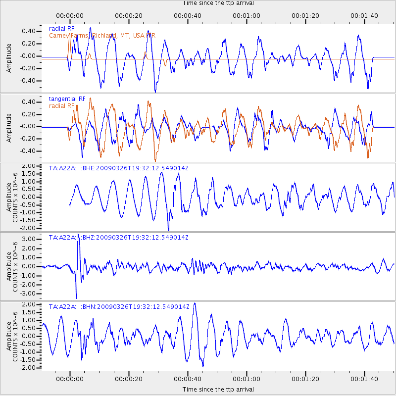
A22A Carney Farms, Richland, MT, USA - Earthquake Result Viewer
*The percent match for this event was below the threshold and hence no stack was calculated.
| Earthquake location: |
Northwest Of Ryukyu Islands |
| Earthquake latitude/longitude: |
27.4/126.7 |
| Earthquake time(UTC): |
2009/03/26 (085) 19:19:59 GMT |
| Earthquake Depth: |
160 km |
| Earthquake Magnitude: |
5.6 MB, 5.9 MW, 5.9 MW |
| Earthquake Catalog/Contributor: |
WHDF/NEIC |
|
| Network: |
TA USArray Transportable Network (new EarthScope stations) |
| Station: |
A22A Carney Farms, Richland, MT, USA |
| Lat/Lon: |
48.99 N/105.92 W |
| Elevation: |
861 m |
|
| Distance: |
90.6 deg |
| Az: |
31.561 deg |
| Baz: |
315.057 deg |
| Ray Param: |
$rayparam |
*The percent match for this event was below the threshold and hence was not used in the summary stack. |
|
| Radial Match: |
73.98727 % |
| Radial Bump: |
400 |
| Transverse Match: |
50.998016 % |
| Transverse Bump: |
400 |
| SOD ConfigId: |
2658 |
| Insert Time: |
2010-03-07 00:56:20.368 +0000 |
| GWidth: |
2.5 |
| Max Bumps: |
400 |
| Tol: |
0.001 |
|
Signal To Noise
| Channel | StoN | STA | LTA |
| TA:A22A: :BHZ:20090326T19:32:12.549014Z | 6.3548946 | 1.5511491E-6 | 2.440873E-7 |
| TA:A22A: :BHN:20090326T19:32:12.549014Z | 1.5843332 | 7.955588E-7 | 5.0214106E-7 |
| TA:A22A: :BHE:20090326T19:32:12.549014Z | 1.7531058 | 1.1395571E-6 | 6.5002183E-7 |
| Arrivals |
| Ps | |
| PpPs | |
| PsPs/PpSs | |


