You are here: Home > Network List > IU - Global Seismograph Network (GSN - IRIS/USGS) Stations List
> Station FURI Mt. Furi, Ethiopia > Earthquake Result Viewer
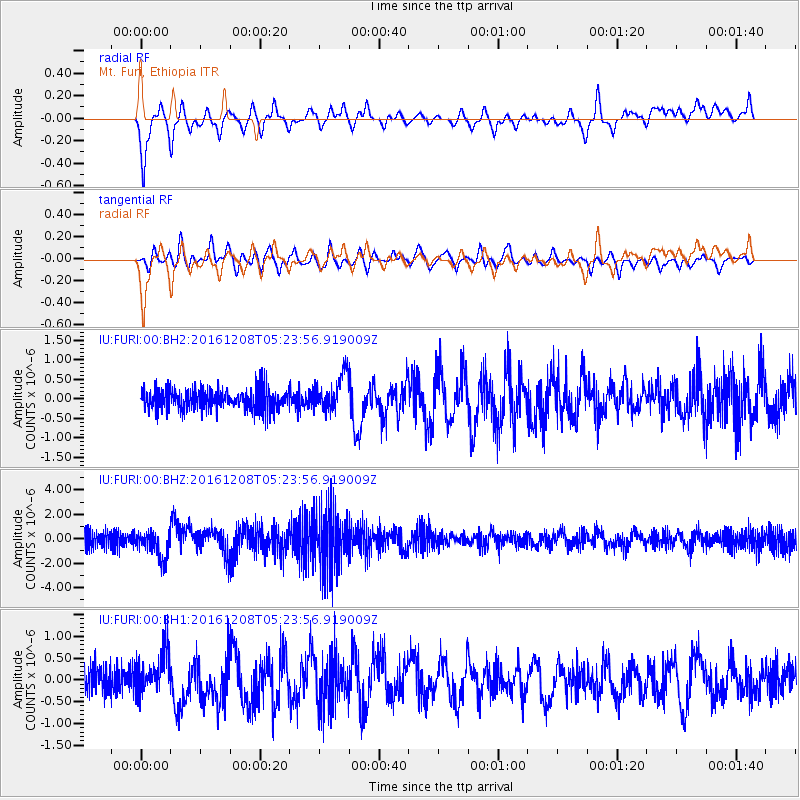
FURI Mt. Furi, Ethiopia - Earthquake Result Viewer
*The percent match for this event was below the threshold and hence no stack was calculated.
| Earthquake location: |
Northern Xinjiang, China |
| Earthquake latitude/longitude: |
43.8/86.3 |
| Earthquake time(UTC): |
2016/12/08 (343) 05:15:04 GMT |
| Earthquake Depth: |
14 km |
| Earthquake Magnitude: |
5.9 Mwp |
| Earthquake Catalog/Contributor: |
NEIC PDE/us |
|
| Network: |
IU Global Seismograph Network (GSN - IRIS/USGS) |
| Station: |
FURI Mt. Furi, Ethiopia |
| Lat/Lon: |
8.90 N/38.68 E |
| Elevation: |
2570 m |
|
| Distance: |
54.0 deg |
| Az: |
244.493 deg |
| Baz: |
41.39 deg |
| Ray Param: |
$rayparam |
*The percent match for this event was below the threshold and hence was not used in the summary stack. |
|
| Radial Match: |
83.567894 % |
| Radial Bump: |
400 |
| Transverse Match: |
72.30613 % |
| Transverse Bump: |
400 |
| SOD ConfigId: |
1894071 |
| Insert Time: |
2016-12-22 05:16:40.602 +0000 |
| GWidth: |
2.5 |
| Max Bumps: |
400 |
| Tol: |
0.001 |
|
Signal To Noise
| Channel | StoN | STA | LTA |
| IU:FURI:00:BHZ:20161208T05:23:56.919009Z | 1.6470674 | 1.1210178E-6 | 6.806144E-7 |
| IU:FURI:00:BH1:20161208T05:23:56.919009Z | 1.7524459 | 5.3550906E-7 | 3.0557806E-7 |
| IU:FURI:00:BH2:20161208T05:23:56.919009Z | 1.7455804 | 4.6981208E-7 | 2.6914375E-7 |
| Arrivals |
| Ps | |
| PpPs | |
| PsPs/PpSs | |


