You are here: Home > Network List > TA - USArray Transportable Network (new EarthScope stations) Stations List
> Station P09A Austin, NV, USA > Earthquake Result Viewer
P09A Austin, NV, USA - Earthquake Result Viewer

| Earthquake location: |
Western Brazil |
| Earthquake latitude/longitude: |
-8.1/-71.3 |
| Earthquake time(UTC): |
2007/07/21 (202) 13:27:04 GMT |
| Earthquake Depth: |
645 km |
| Earthquake Magnitude: |
6.2 MB, 6.1 MW, 6.0 MW |
| Earthquake Catalog/Contributor: |
WHDF/NEIC |
|
| Network: |
TA USArray Transportable Network (new EarthScope stations) |
| Station: |
P09A Austin, NV, USA |
| Lat/Lon: |
39.55 N/117.14 W |
| Elevation: |
1738 m |
|
| Distance: |
63.6 deg |
| Az: |
321.738 deg |
| Baz: |
127.532 deg |
| Ray Param: |
0.056918297 |
| Estimated Moho Depth: |
44.75 km |
| Estimated Crust Vp/Vs: |
1.98 |
| Assumed Crust Vp: |
6.276 km/s |
| Estimated Crust Vs: |
3.166 km/s |
| Estimated Crust Poisson's Ratio: |
0.33 |
|
| Radial Match: |
83.901436 % |
| Radial Bump: |
400 |
| Transverse Match: |
77.534744 % |
| Transverse Bump: |
400 |
| SOD ConfigId: |
2564 |
| Insert Time: |
2010-03-07 00:56:52.795 +0000 |
| GWidth: |
2.5 |
| Max Bumps: |
400 |
| Tol: |
0.001 |
|
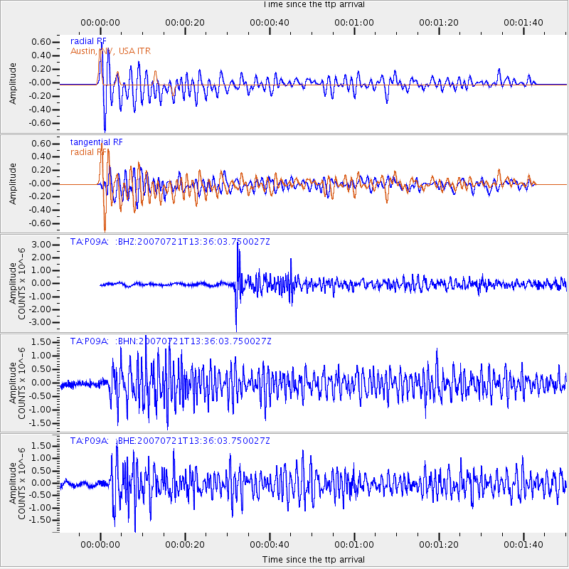
Signal To Noise
| Channel | StoN | STA | LTA |
| TA:P09A: :BHN:20070721T13:36:03.750027Z | 6.8598723 | 4.8034985E-7 | 7.002314E-8 |
| TA:P09A: :BHE:20070721T13:36:03.750027Z | 8.554911 | 6.484614E-7 | 7.57999E-8 |
| TA:P09A: :BHZ:20070721T13:36:03.750027Z | 12.040385 | 9.83781E-7 | 8.1706766E-8 |
| Arrivals |
| Ps | 7.2 SECOND |
| PpPs | 21 SECOND |
| PsPs/PpSs | 28 SECOND |


