You are here: Home > Network List > TA - USArray Transportable Network (new EarthScope stations) Stations List
> Station P09A Austin, NV, USA > Earthquake Result Viewer
P09A Austin, NV, USA - Earthquake Result Viewer

| Earthquake location: |
Northern Colombia |
| Earthquake latitude/longitude: |
7.2/-72.1 |
| Earthquake time(UTC): |
2007/07/16 (197) 22:58:23 GMT |
| Earthquake Depth: |
30 km |
| Earthquake Magnitude: |
5.5 MB, 4.5 MS, 5.1 MW, 5.6 ML |
| Earthquake Catalog/Contributor: |
WHDF/NEIC |
|
| Network: |
TA USArray Transportable Network (new EarthScope stations) |
| Station: |
P09A Austin, NV, USA |
| Lat/Lon: |
39.55 N/117.14 W |
| Elevation: |
1738 m |
|
| Distance: |
51.6 deg |
| Az: |
315.755 deg |
| Baz: |
116.432 deg |
| Ray Param: |
0.067253515 |
| Estimated Moho Depth: |
26.25 km |
| Estimated Crust Vp/Vs: |
1.79 |
| Assumed Crust Vp: |
6.276 km/s |
| Estimated Crust Vs: |
3.516 km/s |
| Estimated Crust Poisson's Ratio: |
0.27 |
|
| Radial Match: |
87.44804 % |
| Radial Bump: |
400 |
| Transverse Match: |
83.958084 % |
| Transverse Bump: |
400 |
| SOD ConfigId: |
2564 |
| Insert Time: |
2010-03-07 00:56:55.312 +0000 |
| GWidth: |
2.5 |
| Max Bumps: |
400 |
| Tol: |
0.001 |
|
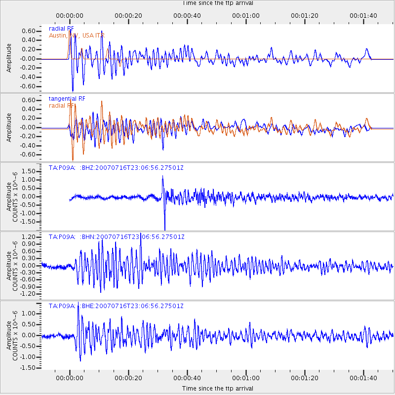
Signal To Noise
| Channel | StoN | STA | LTA |
| TA:P09A: :BHN:20070716T23:06:56.27501Z | 5.8746285 | 3.474474E-7 | 5.9143726E-8 |
| TA:P09A: :BHE:20070716T23:06:56.27501Z | 10.322448 | 5.624866E-7 | 5.4491593E-8 |
| TA:P09A: :BHZ:20070716T23:06:56.27501Z | 8.113866 | 5.230104E-7 | 6.445884E-8 |
| Arrivals |
| Ps | 3.5 SECOND |
| PpPs | 11 SECOND |
| PsPs/PpSs | 15 SECOND |


