You are here: Home > Network List > TA - USArray Transportable Network (new EarthScope stations) Stations List
> Station P09A Austin, NV, USA > Earthquake Result Viewer
P09A Austin, NV, USA - Earthquake Result Viewer
| Earthquake location: |
Peru-Brazil Border Region |
| Earthquake latitude/longitude: |
-7.9/-74.4 |
| Earthquake time(UTC): |
2007/07/12 (193) 05:23:49 GMT |
| Earthquake Depth: |
152 km |
| Earthquake Magnitude: |
5.9 MB, 6.1 MW, 6.0 MW |
| Earthquake Catalog/Contributor: |
WHDF/NEIC |
|
| Network: |
TA USArray Transportable Network (new EarthScope stations) |
| Station: |
P09A Austin, NV, USA |
| Lat/Lon: |
39.55 N/117.14 W |
| Elevation: |
1738 m |
|
| Distance: |
61.6 deg |
| Az: |
323.372 deg |
| Baz: |
130.147 deg |
| Ray Param: |
0.06030601 |
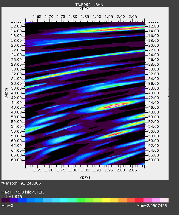
| Estimated Moho Depth: |
45.0 km |
| Estimated Crust Vp/Vs: |
1.98 |
| Assumed Crust Vp: |
6.276 km/s |
| Estimated Crust Vs: |
3.178 km/s |
| Estimated Crust Poisson's Ratio: |
0.33 |
|
| Radial Match: |
91.243385 % |
| Radial Bump: |
400 |
| Transverse Match: |
86.45335 % |
| Transverse Bump: |
400 |
| SOD ConfigId: |
2564 |
| Insert Time: |
2010-03-07 00:57:05.968 +0000 |
| GWidth: |
2.5 |
| Max Bumps: |
400 |
| Tol: |
0.001 |
|
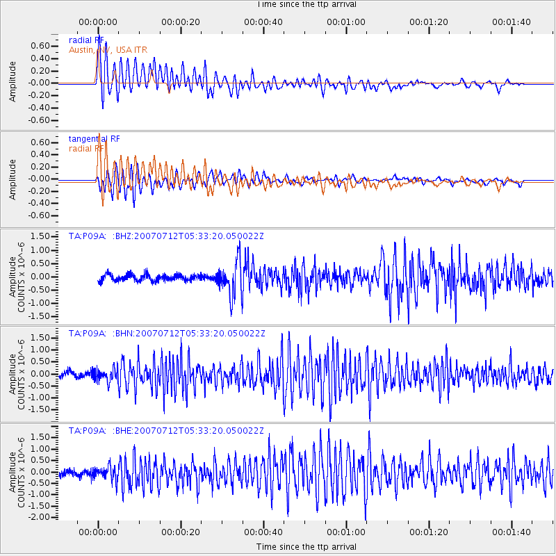
Signal To Noise
| Channel | StoN | STA | LTA |
| TA:P09A: :BHN:20070712T05:33:20.050022Z | 2.1634634 | 2.6062347E-7 | 1.2046587E-7 |
| TA:P09A: :BHE:20070712T05:33:20.050022Z | 2.285462 | 3.0722128E-7 | 1.3442416E-7 |
| TA:P09A: :BHZ:20070712T05:33:20.050022Z | 5.756565 | 6.88431E-7 | 1.1959058E-7 |
| Arrivals |
| Ps | 7.3 SECOND |
| PpPs | 21 SECOND |
| PsPs/PpSs | 28 SECOND |


