You are here: Home > Network List > TA - USArray Transportable Network (new EarthScope stations) Stations List
> Station P09A Austin, NV, USA > Earthquake Result Viewer
P09A Austin, NV, USA - Earthquake Result Viewer
| Earthquake location: |
Near Coast Of Northern Chile |
| Earthquake latitude/longitude: |
-22.9/-70.4 |
| Earthquake time(UTC): |
2007/11/15 (319) 15:03:08 GMT |
| Earthquake Depth: |
27 km |
| Earthquake Magnitude: |
5.8 MB, 6.1 MW, 5.5 ML |
| Earthquake Catalog/Contributor: |
WHDF/NEIC |
|
| Network: |
TA USArray Transportable Network (new EarthScope stations) |
| Station: |
P09A Austin, NV, USA |
| Lat/Lon: |
39.55 N/117.14 W |
| Elevation: |
1738 m |
|
| Distance: |
75.9 deg |
| Az: |
324.516 deg |
| Baz: |
136.172 deg |
| Ray Param: |
0.051326457 |
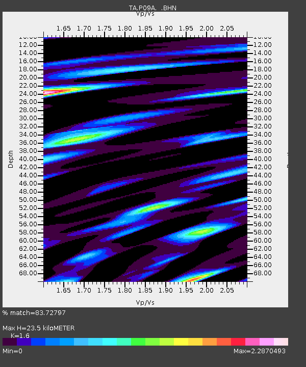
| Estimated Moho Depth: |
23.5 km |
| Estimated Crust Vp/Vs: |
1.60 |
| Assumed Crust Vp: |
6.276 km/s |
| Estimated Crust Vs: |
3.922 km/s |
| Estimated Crust Poisson's Ratio: |
0.18 |
|
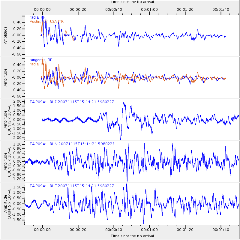
| Radial Match: |
83.72797 % |
| Radial Bump: |
400 |
| Transverse Match: |
75.9922 % |
| Transverse Bump: |
400 |
| SOD ConfigId: |
2564 |
| Insert Time: |
2010-03-07 00:57:16.126 +0000 |
| GWidth: |
2.5 |
| Max Bumps: |
400 |
| Tol: |
0.001 |
|
Signal To Noise
| Channel | StoN | STA | LTA |
| TA:P09A: :BHN:20071115T15:14:21.598022Z | 0.6925352 | 1.2732508E-7 | 1.8385357E-7 |
| TA:P09A: :BHE:20071115T15:14:21.598022Z | 1.3147705 | 2.3511508E-7 | 1.7882596E-7 |
| TA:P09A: :BHZ:20071115T15:14:21.598022Z | 2.789206 | 3.675088E-7 | 1.3176108E-7 |
| Arrivals |
| Ps | 2.3 SECOND |
| PpPs | 9.4 SECOND |
| PsPs/PpSs | 12 SECOND |


