You are here: Home > Network List > TA - USArray Transportable Network (new EarthScope stations) Stations List
> Station I23K Minto, Yukon-Koyukuk, AK, USA > Earthquake Result Viewer
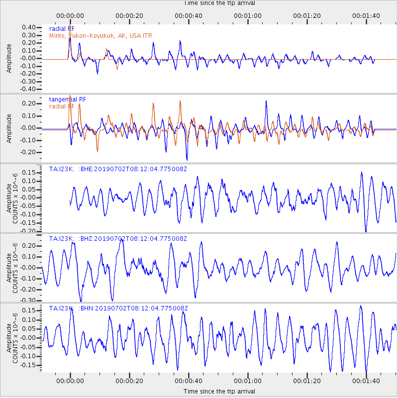
I23K Minto, Yukon-Koyukuk, AK, USA - Earthquake Result Viewer
*The percent match for this event was below the threshold and hence no stack was calculated.
| Earthquake location: |
Santa Cruz Islands |
| Earthquake latitude/longitude: |
-11.5/166.4 |
| Earthquake time(UTC): |
2019/07/02 (183) 08:00:15 GMT |
| Earthquake Depth: |
54 km |
| Earthquake Magnitude: |
5.6 Mww |
| Earthquake Catalog/Contributor: |
NEIC PDE/us |
|
| Network: |
TA USArray Transportable Network (new EarthScope stations) |
| Station: |
I23K Minto, Yukon-Koyukuk, AK, USA |
| Lat/Lon: |
65.15 N/149.36 W |
| Elevation: |
149 m |
|
| Distance: |
83.3 deg |
| Az: |
17.275 deg |
| Baz: |
223.531 deg |
| Ray Param: |
$rayparam |
*The percent match for this event was below the threshold and hence was not used in the summary stack. |
|
| Radial Match: |
67.79091 % |
| Radial Bump: |
288 |
| Transverse Match: |
53.281765 % |
| Transverse Bump: |
352 |
| SOD ConfigId: |
18369291 |
| Insert Time: |
2019-07-16 08:05:15.060 +0000 |
| GWidth: |
2.5 |
| Max Bumps: |
400 |
| Tol: |
0.001 |
|
Signal To Noise
| Channel | StoN | STA | LTA |
| TA:I23K: :BHZ:20190702T08:12:04.775008Z | 2.5663283 | 1.789548E-7 | 6.973185E-8 |
| TA:I23K: :BHN:20190702T08:12:04.775008Z | 1.6266 | 8.220157E-8 | 5.0535824E-8 |
| TA:I23K: :BHE:20190702T08:12:04.775008Z | 1.2015221 | 5.1397418E-8 | 4.2776918E-8 |
| Arrivals |
| Ps | |
| PpPs | |
| PsPs/PpSs | |


