You are here: Home > Network List > TA - USArray Transportable Network (new EarthScope stations) Stations List
> Station P09A Austin, NV, USA > Earthquake Result Viewer
P09A Austin, NV, USA - Earthquake Result Viewer

| Earthquake location: |
Kamchatka Peninsula, Russia |
| Earthquake latitude/longitude: |
52.1/157.3 |
| Earthquake time(UTC): |
2007/05/30 (150) 20:22:12 GMT |
| Earthquake Depth: |
116 km |
| Earthquake Magnitude: |
6.4 MB, 6.4 MW, 6.4 MW |
| Earthquake Catalog/Contributor: |
WHDF/NEIC |
|
| Network: |
TA USArray Transportable Network (new EarthScope stations) |
| Station: |
P09A Austin, NV, USA |
| Lat/Lon: |
39.55 N/117.14 W |
| Elevation: |
1738 m |
|
| Distance: |
57.6 deg |
| Az: |
65.96 deg |
| Baz: |
313.278 deg |
| Ray Param: |
0.063059695 |
| Estimated Moho Depth: |
28.25 km |
| Estimated Crust Vp/Vs: |
1.91 |
| Assumed Crust Vp: |
6.276 km/s |
| Estimated Crust Vs: |
3.277 km/s |
| Estimated Crust Poisson's Ratio: |
0.31 |
|
| Radial Match: |
89.29416 % |
| Radial Bump: |
400 |
| Transverse Match: |
86.115776 % |
| Transverse Bump: |
400 |
| SOD ConfigId: |
2564 |
| Insert Time: |
2010-03-07 00:57:39.435 +0000 |
| GWidth: |
2.5 |
| Max Bumps: |
400 |
| Tol: |
0.001 |
|
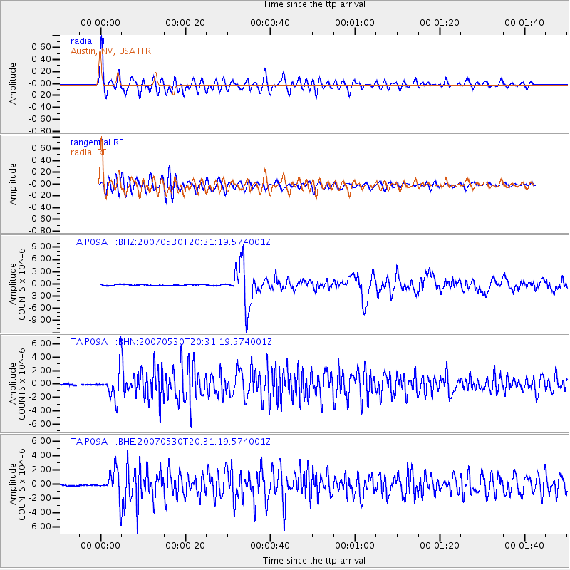
Signal To Noise
| Channel | StoN | STA | LTA |
| TA:P09A: :BHN:20070530T20:31:19.574001Z | 29.058882 | 2.2494742E-6 | 7.74109E-8 |
| TA:P09A: :BHE:20070530T20:31:19.574001Z | 24.224533 | 1.9367278E-6 | 7.9949025E-8 |
| TA:P09A: :BHZ:20070530T20:31:19.574001Z | 64.164024 | 5.064895E-6 | 7.893668E-8 |
| Arrivals |
| Ps | 4.3 SECOND |
| PpPs | 13 SECOND |
| PsPs/PpSs | 17 SECOND |


