You are here: Home > Network List > US - United States National Seismic Network Stations List
> Station MSO Missoula, Montana, USA > Earthquake Result Viewer
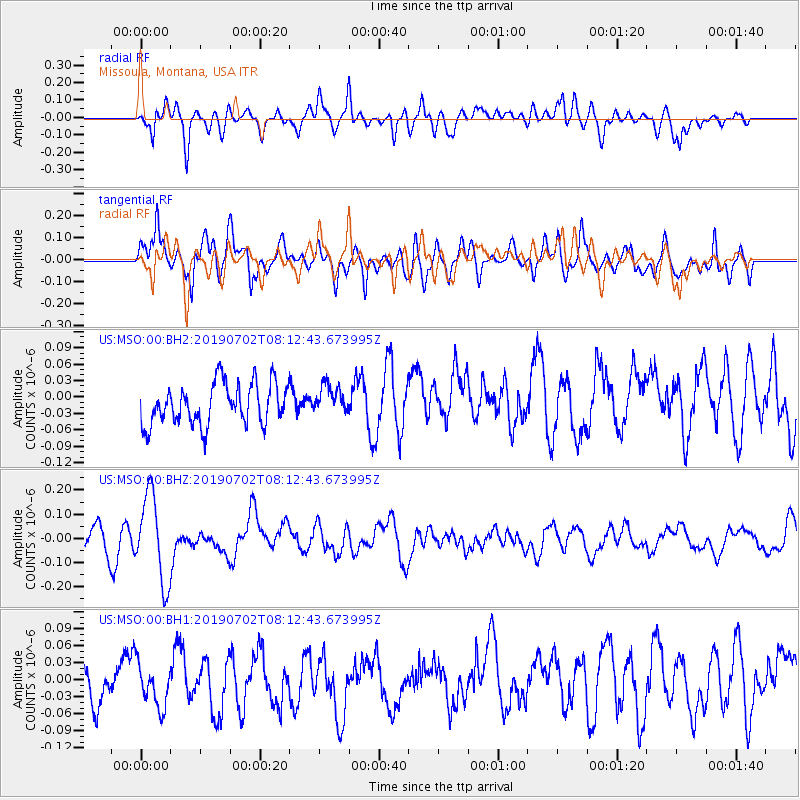
MSO Missoula, Montana, USA - Earthquake Result Viewer
*The percent match for this event was below the threshold and hence no stack was calculated.
| Earthquake location: |
Santa Cruz Islands |
| Earthquake latitude/longitude: |
-11.5/166.4 |
| Earthquake time(UTC): |
2019/07/02 (183) 08:00:15 GMT |
| Earthquake Depth: |
54 km |
| Earthquake Magnitude: |
5.6 Mww |
| Earthquake Catalog/Contributor: |
NEIC PDE/us |
|
| Network: |
US United States National Seismic Network |
| Station: |
MSO Missoula, Montana, USA |
| Lat/Lon: |
46.83 N/113.94 W |
| Elevation: |
1264 m |
|
| Distance: |
91.3 deg |
| Az: |
42.507 deg |
| Baz: |
254.698 deg |
| Ray Param: |
$rayparam |
*The percent match for this event was below the threshold and hence was not used in the summary stack. |
|
| Radial Match: |
59.240147 % |
| Radial Bump: |
400 |
| Transverse Match: |
73.8769 % |
| Transverse Bump: |
400 |
| SOD ConfigId: |
18369291 |
| Insert Time: |
2019-07-16 08:06:17.992 +0000 |
| GWidth: |
2.5 |
| Max Bumps: |
400 |
| Tol: |
0.001 |
|
Signal To Noise
| Channel | StoN | STA | LTA |
| US:MSO:00:BHZ:20190702T08:12:43.673995Z | 3.0225306 | 1.7898255E-7 | 5.9216124E-8 |
| US:MSO:00:BH1:20190702T08:12:43.673995Z | 0.85733795 | 4.1507942E-8 | 4.841491E-8 |
| US:MSO:00:BH2:20190702T08:12:43.673995Z | 0.71101743 | 2.6537853E-8 | 3.7323773E-8 |
| Arrivals |
| Ps | |
| PpPs | |
| PsPs/PpSs | |


