You are here: Home > Network List > TA - USArray Transportable Network (new EarthScope stations) Stations List
> Station P09A Austin, NV, USA > Earthquake Result Viewer
P09A Austin, NV, USA - Earthquake Result Viewer
| Earthquake location: |
Chile-Bolivia Border Region |
| Earthquake latitude/longitude: |
-21.3/-68.5 |
| Earthquake time(UTC): |
2006/06/27 (178) 11:24:36 GMT |
| Earthquake Depth: |
122 km |
| Earthquake Magnitude: |
5.2 MB, 5.5 MW |
| Earthquake Catalog/Contributor: |
WHDF/NEIC |
|
| Network: |
TA USArray Transportable Network (new EarthScope stations) |
| Station: |
P09A Austin, NV, USA |
| Lat/Lon: |
39.55 N/117.14 W |
| Elevation: |
1738 m |
|
| Distance: |
75.7 deg |
| Az: |
323.215 deg |
| Baz: |
133.754 deg |
| Ray Param: |
0.051221084 |
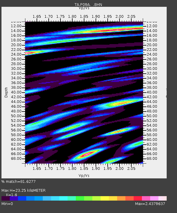
| Estimated Moho Depth: |
23.25 km |
| Estimated Crust Vp/Vs: |
1.60 |
| Assumed Crust Vp: |
6.276 km/s |
| Estimated Crust Vs: |
3.922 km/s |
| Estimated Crust Poisson's Ratio: |
0.18 |
|
| Radial Match: |
81.6277 % |
| Radial Bump: |
400 |
| Transverse Match: |
75.643486 % |
| Transverse Bump: |
400 |
| SOD ConfigId: |
2564 |
| Insert Time: |
2010-03-07 00:57:58.264 +0000 |
| GWidth: |
2.5 |
| Max Bumps: |
400 |
| Tol: |
0.001 |
|

Signal To Noise
| Channel | StoN | STA | LTA |
| TA:P09A: :BHN:20060627T11:35:37.299011Z | 1.9923949 | 1.9049567E-7 | 9.56114E-8 |
| TA:P09A: :BHE:20060627T11:35:37.299011Z | 4.4370875 | 2.6948632E-7 | 6.073496E-8 |
| TA:P09A: :BHZ:20060627T11:35:37.299011Z | 3.4826758 | 3.309811E-7 | 9.5036434E-8 |
| Arrivals |
| Ps | 2.3 SECOND |
| PpPs | 9.3 SECOND |
| PsPs/PpSs | 12 SECOND |


