You are here: Home > Network List > TA - USArray Transportable Network (new EarthScope stations) Stations List
> Station P09A Austin, NV, USA > Earthquake Result Viewer
P09A Austin, NV, USA - Earthquake Result Viewer
| Earthquake location: |
Tonga Islands |
| Earthquake latitude/longitude: |
-20.6/-173.9 |
| Earthquake time(UTC): |
2006/05/17 (137) 03:06:16 GMT |
| Earthquake Depth: |
10 km |
| Earthquake Magnitude: |
5.8 MB, 5.8 MS, 6.0 MW, 5.8 MW |
| Earthquake Catalog/Contributor: |
WHDF/NEIC |
|
| Network: |
TA USArray Transportable Network (new EarthScope stations) |
| Station: |
P09A Austin, NV, USA |
| Lat/Lon: |
39.55 N/117.14 W |
| Elevation: |
1738 m |
|
| Distance: |
80.0 deg |
| Az: |
41.076 deg |
| Baz: |
232.749 deg |
| Ray Param: |
0.04859758 |
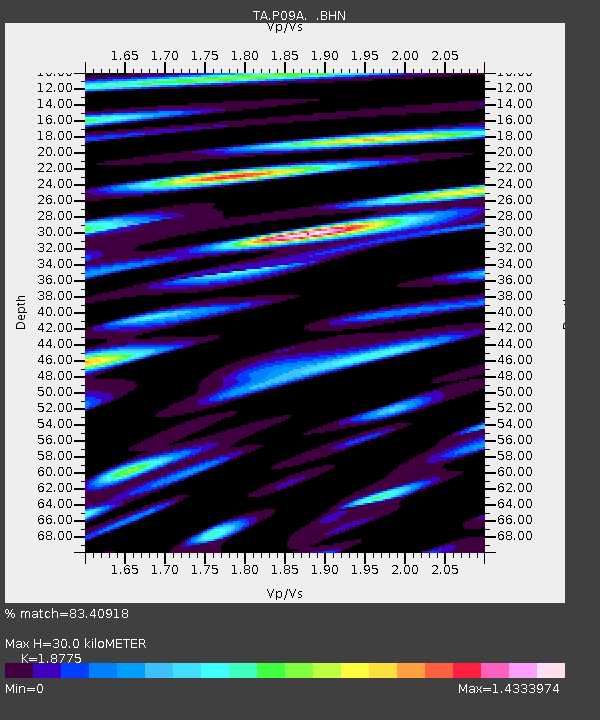
| Estimated Moho Depth: |
30.0 km |
| Estimated Crust Vp/Vs: |
1.88 |
| Assumed Crust Vp: |
6.276 km/s |
| Estimated Crust Vs: |
3.343 km/s |
| Estimated Crust Poisson's Ratio: |
0.30 |
|
| Radial Match: |
83.40918 % |
| Radial Bump: |
400 |
| Transverse Match: |
60.781944 % |
| Transverse Bump: |
400 |
| SOD ConfigId: |
2669 |
| Insert Time: |
2010-03-07 00:58:28.121 +0000 |
| GWidth: |
2.5 |
| Max Bumps: |
400 |
| Tol: |
0.001 |
|

Signal To Noise
| Channel | StoN | STA | LTA |
| TA:P09A: :BHN:20060517T03:17:54.023018Z | 2.703464 | 2.7681256E-7 | 1.0239181E-7 |
| TA:P09A: :BHE:20060517T03:17:54.023018Z | 2.6524322 | 2.953099E-7 | 1.1133552E-7 |
| TA:P09A: :BHZ:20060517T03:17:54.023018Z | 8.343959 | 6.66752E-7 | 7.990835E-8 |
| Arrivals |
| Ps | 4.3 SECOND |
| PpPs | 13 SECOND |
| PsPs/PpSs | 18 SECOND |


