You are here: Home > Network List > TA - USArray Transportable Network (new EarthScope stations) Stations List
> Station K02A Glendale, OR, USA > Earthquake Result Viewer
K02A Glendale, OR, USA - Earthquake Result Viewer
| Earthquake location: |
Kuril Islands |
| Earthquake latitude/longitude: |
45.8/150.1 |
| Earthquake time(UTC): |
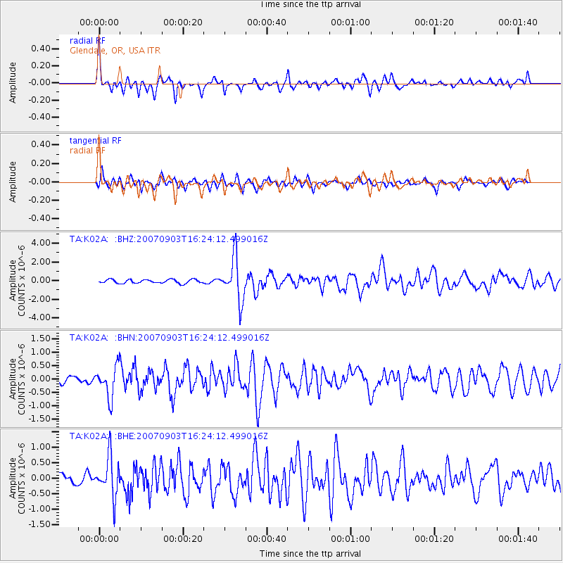
2007/09/03 (246) 16:14:53 GMT |
| Earthquake Depth: |
94 km |
| Earthquake Magnitude: |
6.3 MB, 6.2 MW, 6.2 ME |
| Earthquake Catalog/Contributor: |
WHDF/NEIC |
|
| Network: |
TA USArray Transportable Network (new EarthScope stations) |
| Station: |
K02A Glendale, OR, USA |
| Lat/Lon: |
42.77 N/123.49 W |
| Elevation: |
963 m |
|
| Distance: |
59.0 deg |
| Az: |
59.07 deg |
| Baz: |
305.474 deg |
| Ray Param: |
0.062232878 |
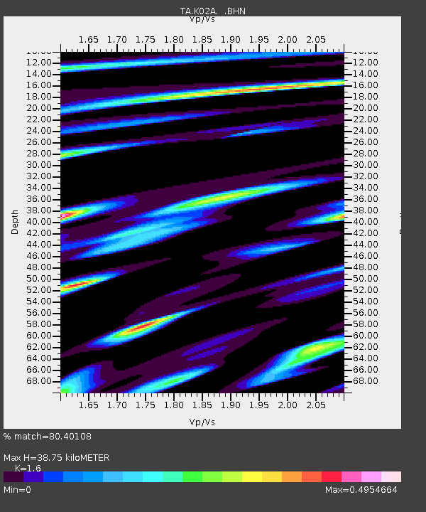
| Estimated Moho Depth: |
38.75 km |
| Estimated Crust Vp/Vs: |
1.60 |
| Assumed Crust Vp: |
6.522 km/s |
| Estimated Crust Vs: |
4.076 km/s |
| Estimated Crust Poisson's Ratio: |
0.18 |
|
| Radial Match: |
80.40108 % |
| Radial Bump: |
400 |
| Transverse Match: |
75.963715 % |
| Transverse Bump: |
400 |
| SOD ConfigId: |
2564 |
| Insert Time: |
2010-03-07 00:58:42.749 +0000 |
| GWidth: |
2.5 |
| Max Bumps: |
400 |
| Tol: |
0.001 |
|
Signal To Noise
| Channel | StoN | STA | LTA |
| TA:K02A: :BHN:20070903T16:24:12.499016Z | 5.2839284 | 5.9546437E-7 | 1.12693506E-7 |
| TA:K02A: :BHE:20070903T16:24:12.499016Z | 3.6868875 | 6.5517264E-7 | 1.7770346E-7 |
| TA:K02A: :BHZ:20070903T16:24:12.499016Z | 11.875441 | 2.357224E-6 | 1.9849571E-7 |
| Arrivals |
| Ps | 3.8 SECOND |
| PpPs | 15 SECOND |
| PsPs/PpSs | 18 SECOND |


