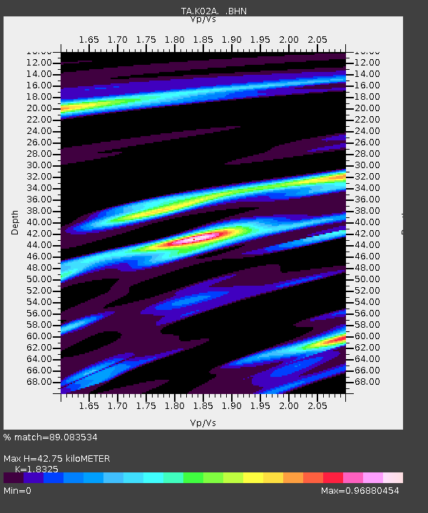
K02A Glendale, OR, USA - Earthquake Result Viewer
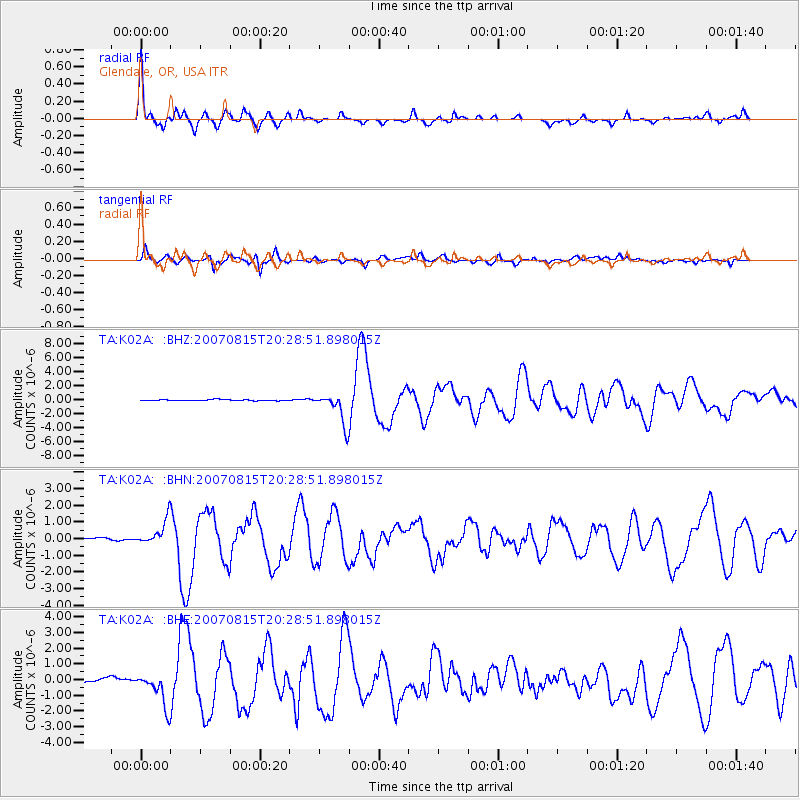
Earthquake location: Andreanof Islands, Aleutian Is.
Earthquake latitude/longitude: 50.3/-177.5
Earthquake time(UTC): 2007/08/15 (227) 20:22:11 GMT
Earthquake Depth: 9.0 km
Earthquake Magnitude: 6.3 MB, 6.2 MS, 6.4 MW, 5.9 ML
Earthquake Catalog/Contributor: WHDF/NEIC
Network: TA USArray Transportable Network (new EarthScope stations)
Station: K02A Glendale, OR, USA
Lat/Lon: 42.77 N/123.49 W
Elevation: 963 m
Distance: 37.2 deg
Az: 80.299 deg
Baz: 300.904 deg
Ray Param: 0.07625837
Estimated Moho Depth: 42.75 km
Estimated Crust Vp/Vs: 1.83
Assumed Crust Vp: 6.522 km/s
Estimated Crust Vs: 3.559 km/s
Estimated Crust Poisson's Ratio: 0.29
Radial Match: 89.083534 %
Radial Bump: 323
Transverse Match: 84.2319 %
Transverse Bump: 400
SOD ConfigId: 2564
Insert Time: 2010-03-07 00:58:50.900 +0000
GWidth: 2.5
Max Bumps: 400
Tol: 0.001

Signal To Noise

ChannelStoNSTALTA
TA:K02A: :BHN:20070815T20:28:51.898015Z9.9306417.6353973E-77.6887254E-8
TA:K02A: :BHE:20070815T20:28:51.898015Z5.5307591.0319357E-61.8658122E-7
TA:K02A: :BHZ:20070815T20:28:51.898015Z30.1851712.210788E-67.324086E-8
Arrivals
Ps5.9 SECOND
PpPs17 SECOND
PsPs/PpSs23 SECOND