You are here: Home > Network List > TA - USArray Transportable Network (new EarthScope stations) Stations List
> Station K02A Glendale, OR, USA > Earthquake Result Viewer
K02A Glendale, OR, USA - Earthquake Result Viewer
| Earthquake location: |
Vanuatu Islands |
| Earthquake latitude/longitude: |
-15.6/167.7 |
| Earthquake time(UTC): |
2007/08/01 (213) 17:08:51 GMT |
| Earthquake Depth: |
120 km |
| Earthquake Magnitude: |
6.2 MB, 7.2 MW, 7.2 MW |
| Earthquake Catalog/Contributor: |
WHDF/NEIC |
|
| Network: |
TA USArray Transportable Network (new EarthScope stations) |
| Station: |
K02A Glendale, OR, USA |
| Lat/Lon: |
42.77 N/123.49 W |
| Elevation: |
963 m |
|
| Distance: |
85.7 deg |
| Az: |
43.524 deg |
| Baz: |
244.315 deg |
| Ray Param: |
0.04433886 |
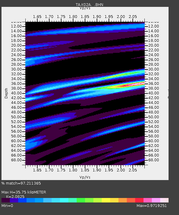
| Estimated Moho Depth: |
35.75 km |
| Estimated Crust Vp/Vs: |
2.08 |
| Assumed Crust Vp: |
6.522 km/s |
| Estimated Crust Vs: |
3.132 km/s |
| Estimated Crust Poisson's Ratio: |
0.35 |
|
| Radial Match: |
97.211365 % |
| Radial Bump: |
397 |
| Transverse Match: |
88.42633 % |
| Transverse Bump: |
400 |
| SOD ConfigId: |
2564 |
| Insert Time: |
2010-03-07 00:58:56.857 +0000 |
| GWidth: |
2.5 |
| Max Bumps: |
400 |
| Tol: |
0.001 |
|
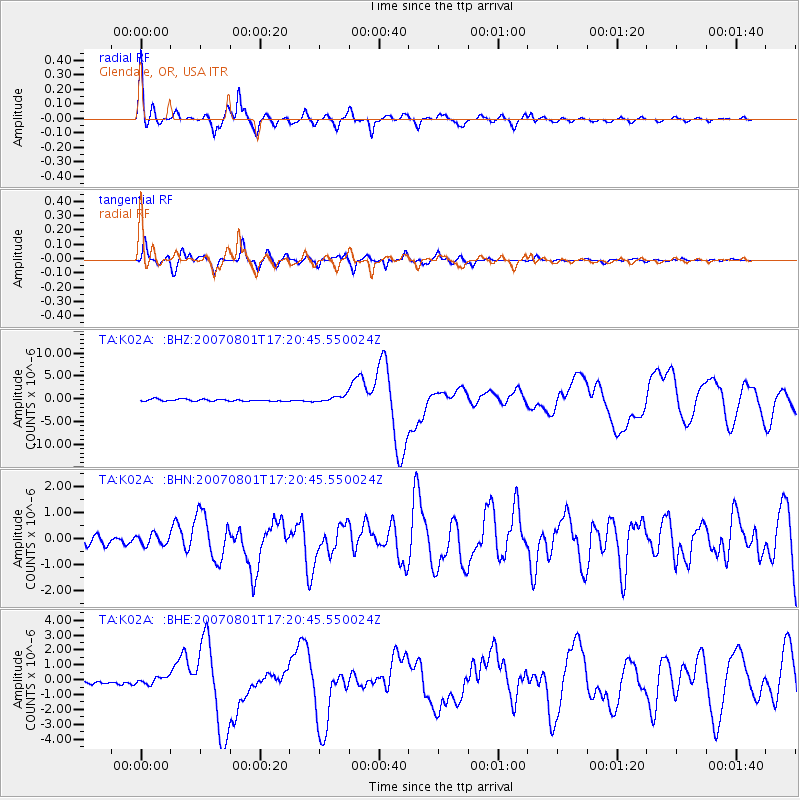
Signal To Noise
| Channel | StoN | STA | LTA |
| TA:K02A: :BHN:20070801T17:20:45.550024Z | 1.1903329 | 2.0197851E-7 | 1.6968237E-7 |
| TA:K02A: :BHE:20070801T17:20:45.550024Z | 2.1281142 | 2.5404356E-7 | 1.1937496E-7 |
| TA:K02A: :BHZ:20070801T17:20:45.550024Z | 3.4848654 | 7.2727005E-7 | 2.0869386E-7 |
| Arrivals |
| Ps | 6.1 SECOND |
| PpPs | 17 SECOND |
| PsPs/PpSs | 23 SECOND |


