You are here: Home > Network List > TA - USArray Transportable Network (new EarthScope stations) Stations List
> Station K02A Glendale, OR, USA > Earthquake Result Viewer
K02A Glendale, OR, USA - Earthquake Result Viewer
| Earthquake location: |
South Of Fiji Islands |
| Earthquake latitude/longitude: |
-26.2/-177.7 |
| Earthquake time(UTC): |
2007/07/17 (198) 09:39:27 GMT |
| Earthquake Depth: |
10 km |
| Earthquake Magnitude: |
5.7 MB, 6.0 MS, 6.1 MW, 6.0 MW |
| Earthquake Catalog/Contributor: |
WHDF/NEIC |
|
| Network: |
TA USArray Transportable Network (new EarthScope stations) |
| Station: |
K02A Glendale, OR, USA |
| Lat/Lon: |
42.77 N/123.49 W |
| Elevation: |
963 m |
|
| Distance: |
84.9 deg |
| Az: |
36.875 deg |
| Baz: |
227.06 deg |
| Ray Param: |
0.04516885 |
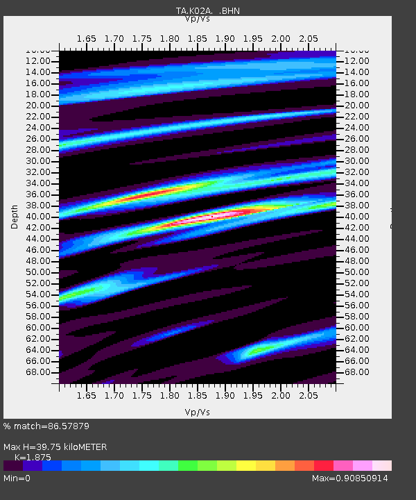
| Estimated Moho Depth: |
39.75 km |
| Estimated Crust Vp/Vs: |
1.88 |
| Assumed Crust Vp: |
6.522 km/s |
| Estimated Crust Vs: |
3.478 km/s |
| Estimated Crust Poisson's Ratio: |
0.30 |
|
| Radial Match: |
86.57879 % |
| Radial Bump: |
400 |
| Transverse Match: |
75.8809 % |
| Transverse Bump: |
400 |
| SOD ConfigId: |
2564 |
| Insert Time: |
2010-03-07 00:59:00.619 +0000 |
| GWidth: |
2.5 |
| Max Bumps: |
400 |
| Tol: |
0.001 |
|
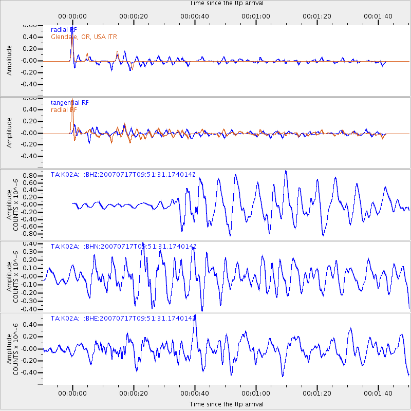
Signal To Noise
| Channel | StoN | STA | LTA |
| TA:K02A: :BHN:20070717T09:51:31.174014Z | 1.9226156 | 7.3508566E-8 | 3.8233626E-8 |
| TA:K02A: :BHE:20070717T09:51:31.174014Z | 0.9387921 | 6.6243906E-8 | 7.056291E-8 |
| TA:K02A: :BHZ:20070717T09:51:31.174014Z | 1.9921238 | 9.788913E-8 | 4.9138077E-8 |
| Arrivals |
| Ps | 5.5 SECOND |
| PpPs | 17 SECOND |
| PsPs/PpSs | 23 SECOND |


