You are here: Home > Network List > TA - USArray Transportable Network (new EarthScope stations) Stations List
> Station K02A Glendale, OR, USA > Earthquake Result Viewer
K02A Glendale, OR, USA - Earthquake Result Viewer
| Earthquake location: |
Solomon Islands |
| Earthquake latitude/longitude: |
-8.0/154.6 |
| Earthquake time(UTC): |
2007/06/28 (179) 02:52:09 GMT |
| Earthquake Depth: |
10 km |
| Earthquake Magnitude: |
6.3 MB, 6.7 MS, 6.7 MW, 6.7 MW |
| Earthquake Catalog/Contributor: |
WHDF/NEIC |
|
| Network: |
TA USArray Transportable Network (new EarthScope stations) |
| Station: |
K02A Glendale, OR, USA |
| Lat/Lon: |
42.77 N/123.49 W |
| Elevation: |
963 m |
|
| Distance: |
89.4 deg |
| Az: |
46.806 deg |
| Baz: |
258.692 deg |
| Ray Param: |
0.041851386 |
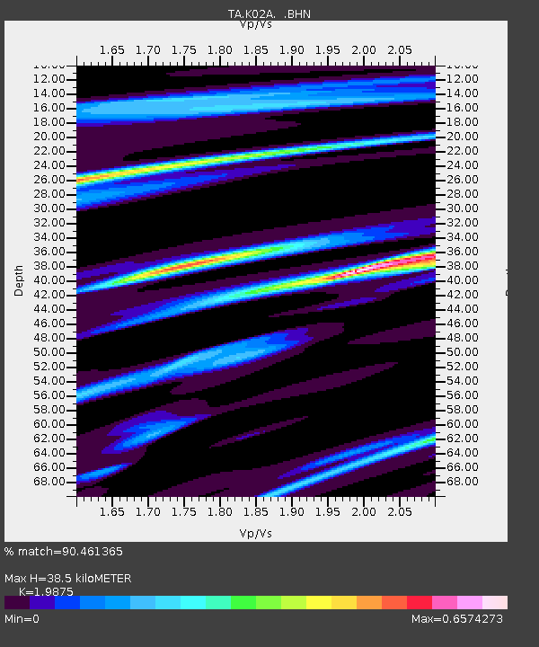
| Estimated Moho Depth: |
38.5 km |
| Estimated Crust Vp/Vs: |
1.99 |
| Assumed Crust Vp: |
6.522 km/s |
| Estimated Crust Vs: |
3.281 km/s |
| Estimated Crust Poisson's Ratio: |
0.33 |
|
| Radial Match: |
90.461365 % |
| Radial Bump: |
353 |
| Transverse Match: |
86.67711 % |
| Transverse Bump: |
387 |
| SOD ConfigId: |
2564 |
| Insert Time: |
2010-03-07 00:59:11.256 +0000 |
| GWidth: |
2.5 |
| Max Bumps: |
400 |
| Tol: |
0.001 |
|
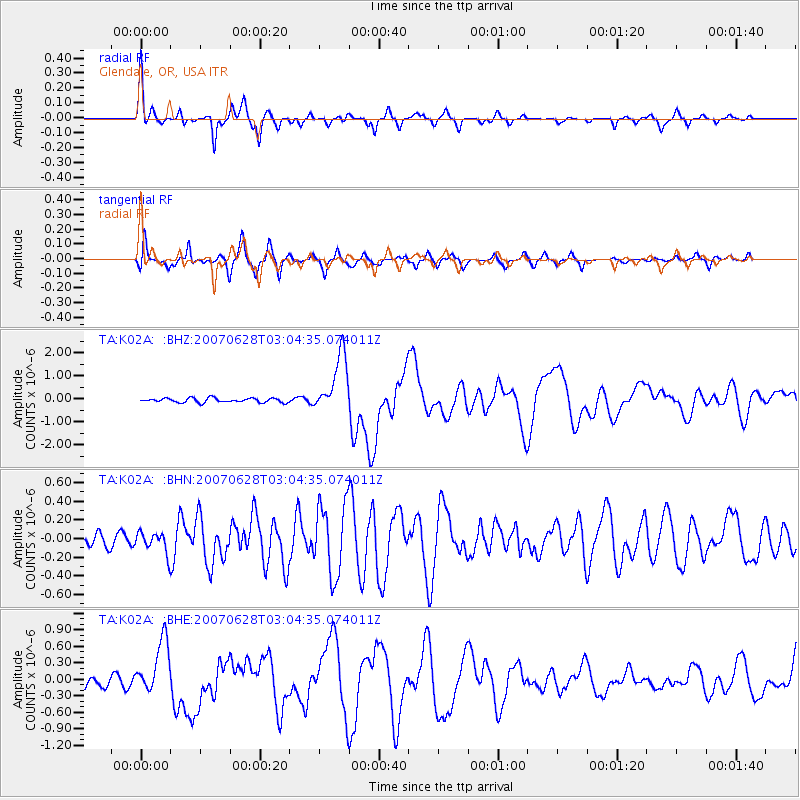
Signal To Noise
| Channel | StoN | STA | LTA |
| TA:K02A: :BHN:20070628T03:04:35.074011Z | 1.0461193 | 1.11175524E-7 | 1.0627422E-7 |
| TA:K02A: :BHE:20070628T03:04:35.074011Z | 4.7921467 | 4.7666606E-7 | 9.946817E-8 |
| TA:K02A: :BHZ:20070628T03:04:35.074011Z | 13.301749 | 1.2706398E-6 | 9.5524264E-8 |
| Arrivals |
| Ps | 5.9 SECOND |
| PpPs | 17 SECOND |
| PsPs/PpSs | 23 SECOND |


