You are here: Home > Network List > TA - USArray Transportable Network (new EarthScope stations) Stations List
> Station K02A Glendale, OR, USA > Earthquake Result Viewer
K02A Glendale, OR, USA - Earthquake Result Viewer
| Earthquake location: |
Mariana Islands |
| Earthquake latitude/longitude: |
21.0/144.7 |
| Earthquake time(UTC): |
2007/01/30 (030) 21:37:45 GMT |
| Earthquake Depth: |
30 km |
| Earthquake Magnitude: |
6.3 MB, 6.5 MS, 6.6 MW, 6.5 MW |
| Earthquake Catalog/Contributor: |
WHDF/NEIC |
|
| Network: |
TA USArray Transportable Network (new EarthScope stations) |
| Station: |
K02A Glendale, OR, USA |
| Lat/Lon: |
42.77 N/123.49 W |
| Elevation: |
963 m |
|
| Distance: |
77.3 deg |
| Az: |
48.969 deg |
| Baz: |
286.811 deg |
| Ray Param: |
0.050346132 |
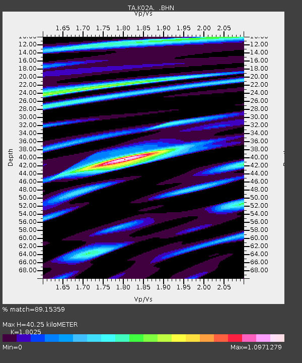
| Estimated Moho Depth: |
40.25 km |
| Estimated Crust Vp/Vs: |
1.80 |
| Assumed Crust Vp: |
6.522 km/s |
| Estimated Crust Vs: |
3.618 km/s |
| Estimated Crust Poisson's Ratio: |
0.28 |
|
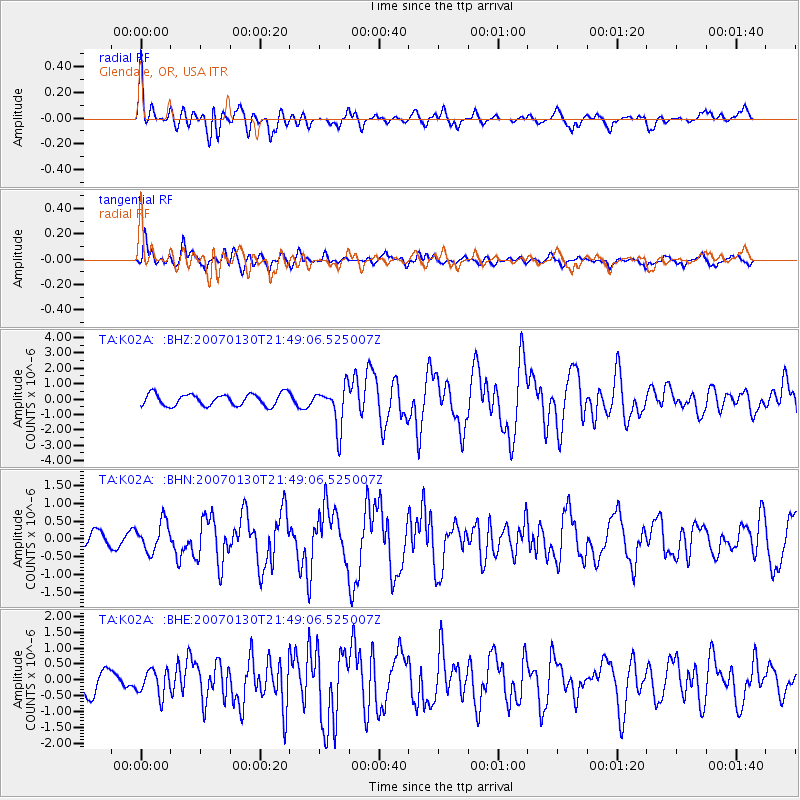
| Radial Match: |
89.15359 % |
| Radial Bump: |
400 |
| Transverse Match: |
78.312515 % |
| Transverse Bump: |
400 |
| SOD ConfigId: |
2564 |
| Insert Time: |
2010-03-07 00:59:17.299 +0000 |
| GWidth: |
2.5 |
| Max Bumps: |
400 |
| Tol: |
0.001 |
|
Signal To Noise
| Channel | StoN | STA | LTA |
| TA:K02A: :BHN:20070130T21:49:06.525007Z | 1.2534537 | 4.0953518E-7 | 3.267254E-7 |
| TA:K02A: :BHE:20070130T21:49:06.525007Z | 1.5878619 | 4.0105758E-7 | 2.525771E-7 |
| TA:K02A: :BHZ:20070130T21:49:06.525007Z | 3.470518 | 1.33681E-6 | 3.8519033E-7 |
| Arrivals |
| Ps | 5.1 SECOND |
| PpPs | 17 SECOND |
| PsPs/PpSs | 22 SECOND |


