You are here: Home > Network List > TA - USArray Transportable Network (new EarthScope stations) Stations List
> Station K02A Glendale, OR, USA > Earthquake Result Viewer
K02A Glendale, OR, USA - Earthquake Result Viewer
| Earthquake location: |
Kuril Islands |
| Earthquake latitude/longitude: |
46.3/153.3 |
| Earthquake time(UTC): |
2006/10/13 (286) 13:47:39 GMT |
| Earthquake Depth: |
8.0 km |
| Earthquake Magnitude: |
5.5 MB, 5.8 MS, 6.3 MW, 5.8 MW |
| Earthquake Catalog/Contributor: |
WHDF/NEIC |
|
| Network: |
TA USArray Transportable Network (new EarthScope stations) |
| Station: |
K02A Glendale, OR, USA |
| Lat/Lon: |
42.77 N/123.49 W |
| Elevation: |
963 m |
|
| Distance: |
56.8 deg |
| Az: |
60.903 deg |
| Baz: |
304.575 deg |
| Ray Param: |
0.06390171 |
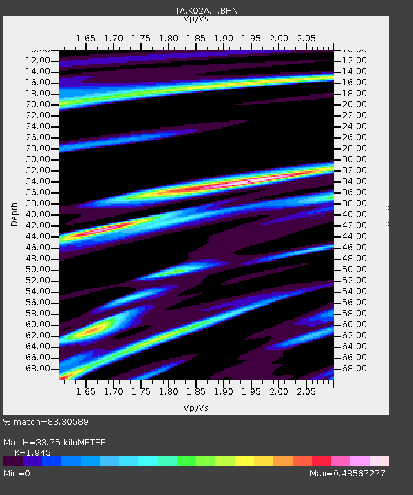
| Estimated Moho Depth: |
33.75 km |
| Estimated Crust Vp/Vs: |
1.95 |
| Assumed Crust Vp: |
6.522 km/s |
| Estimated Crust Vs: |
3.353 km/s |
| Estimated Crust Poisson's Ratio: |
0.32 |
|
| Radial Match: |
83.30589 % |
| Radial Bump: |
341 |
| Transverse Match: |
68.119934 % |
| Transverse Bump: |
400 |
| SOD ConfigId: |
2665 |
| Insert Time: |
2010-03-07 00:59:26.846 +0000 |
| GWidth: |
2.5 |
| Max Bumps: |
400 |
| Tol: |
0.001 |
|
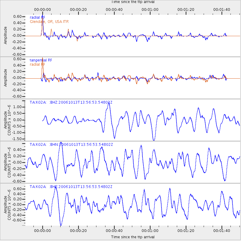
Signal To Noise
| Channel | StoN | STA | LTA |
| TA:K02A: :BHN:20061013T13:56:53.54802Z | 1.0894779 | 1.5936574E-7 | 1.4627717E-7 |
| TA:K02A: :BHE:20061013T13:56:53.54802Z | 1.4125627 | 2.1447428E-7 | 1.5183346E-7 |
| TA:K02A: :BHZ:20061013T13:56:53.54802Z | 2.3166234 | 3.8325507E-7 | 1.6543692E-7 |
| Arrivals |
| Ps | 5.1 SECOND |
| PpPs | 15 SECOND |
| PsPs/PpSs | 20 SECOND |


