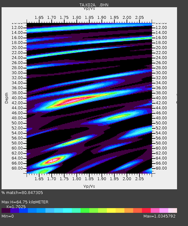
K02A Glendale, OR, USA - Earthquake Result Viewer
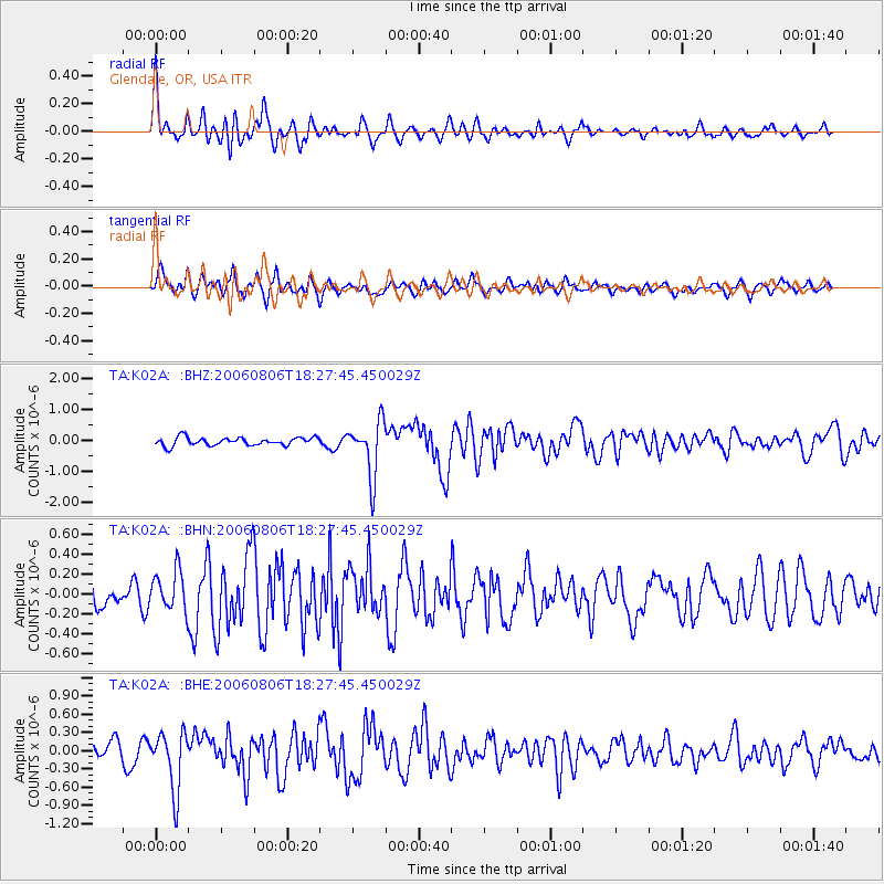
Earthquake location: Bonin Islands, Japan Region
Earthquake latitude/longitude: 26.1/144.0
Earthquake time(UTC): 2006/08/06 (218) 18:16:40 GMT
Earthquake Depth: 23 km
Earthquake Magnitude: 6.0 MB, 5.6 MS, 5.8 MW, 5.8 MW
Earthquake Catalog/Contributor: WHDF/NEIC
Network: TA USArray Transportable Network (new EarthScope stations)
Station: K02A Glendale, OR, USA
Lat/Lon: 42.77 N/123.49 W
Elevation: 963 m
Distance: 74.5 deg
Az: 49.772 deg
Baz: 291.234 deg
Ray Param: 0.05226975
Estimated Moho Depth: 64.75 km
Estimated Crust Vp/Vs: 1.70
Assumed Crust Vp: 6.522 km/s
Estimated Crust Vs: 3.831 km/s
Estimated Crust Poisson's Ratio: 0.24
Radial Match: 80.847305 %
Radial Bump: 400
Transverse Match: 59.98639 %
Transverse Bump: 400
SOD ConfigId: 2665
Insert Time: 2010-03-07 00:59:32.502 +0000
GWidth: 2.5
Max Bumps: 400
Tol: 0.001

Signal To Noise

ChannelStoNSTALTA
TA:K02A: :BHN:20060806T18:27:45.450029Z2.06760762.0250128E-79.79399E-8
TA:K02A: :BHE:20060806T18:27:45.450029Z3.79050454.795173E-71.2650489E-7
TA:K02A: :BHZ:20060806T18:27:45.450029Z6.8929588.9666986E-71.3008491E-7
Arrivals
Ps7.2 SECOND
PpPs26 SECOND
PsPs/PpSs33 SECOND