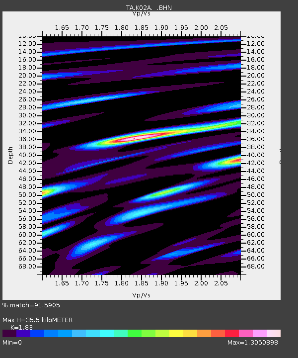
K02A Glendale, OR, USA - Earthquake Result Viewer
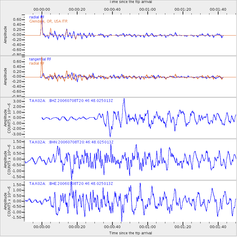
Earthquake location: Andreanof Islands, Aleutian Is.
Earthquake latitude/longitude: 51.2/-179.3
Earthquake time(UTC): 2006/07/08 (189) 20:40:00 GMT
Earthquake Depth: 22 km
Earthquake Magnitude: 6.2 MB, 6.4 MS, 6.6 MW, 6.6 MW
Earthquake Catalog/Contributor: WHDF/NEIC
Network: TA USArray Transportable Network (new EarthScope stations)
Station: K02A Glendale, OR, USA
Lat/Lon: 42.77 N/123.49 W
Elevation: 963 m
Distance: 38.2 deg
Az: 80.319 deg
Baz: 302.653 deg
Ray Param: 0.075684376
Estimated Moho Depth: 35.5 km
Estimated Crust Vp/Vs: 1.83
Assumed Crust Vp: 6.522 km/s
Estimated Crust Vs: 3.564 km/s
Estimated Crust Poisson's Ratio: 0.29
Radial Match: 91.5905 %
Radial Bump: 400
Transverse Match: 74.01499 %
Transverse Bump: 400
SOD ConfigId: 2665
Insert Time: 2010-03-07 00:59:35.327 +0000
GWidth: 2.5
Max Bumps: 400
Tol: 0.001

Signal To Noise

ChannelStoNSTALTA
TA:K02A: :BHN:20060708T20:46:48.025013Z1.25091041.865179E-71.4910572E-7
TA:K02A: :BHE:20060708T20:46:48.025013Z1.24670661.9064117E-71.5291582E-7
TA:K02A: :BHZ:20060708T20:46:48.025013Z2.51902634.5492817E-71.8059684E-7
Arrivals
Ps4.9 SECOND
PpPs14 SECOND
PsPs/PpSs19 SECOND