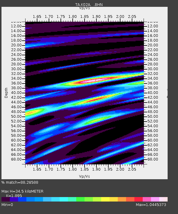
K02A Glendale, OR, USA - Earthquake Result Viewer
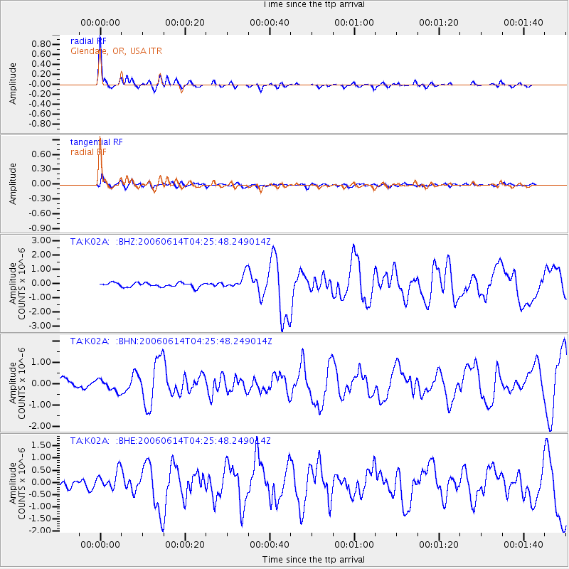
Earthquake location: Rat Islands, Aleutian Islands
Earthquake latitude/longitude: 51.8/177.1
Earthquake time(UTC): 2006/06/14 (165) 04:18:42 GMT
Earthquake Depth: 14 km
Earthquake Magnitude: 5.9 MB, 6.4 MS, 6.4 MW, 6.4 MW
Earthquake Catalog/Contributor: WHDF/NEIC
Network: TA USArray Transportable Network (new EarthScope stations)
Station: K02A Glendale, OR, USA
Lat/Lon: 42.77 N/123.49 W
Elevation: 963 m
Distance: 40.3 deg
Az: 78.657 deg
Baz: 304.14 deg
Ray Param: 0.074472636
Estimated Moho Depth: 34.5 km
Estimated Crust Vp/Vs: 1.89
Assumed Crust Vp: 6.522 km/s
Estimated Crust Vs: 3.441 km/s
Estimated Crust Poisson's Ratio: 0.31
Radial Match: 88.26588 %
Radial Bump: 272
Transverse Match: 55.5154 %
Transverse Bump: 400
SOD ConfigId: 5745
Insert Time: 2010-03-07 00:59:38.726 +0000
GWidth: 2.5
Max Bumps: 400
Tol: 0.001

Signal To Noise

ChannelStoNSTALTA
TA:K02A: :BHN:20060614T04:25:48.249014Z1.20721242.8524963E-72.3628786E-7
TA:K02A: :BHE:20060614T04:25:48.249014Z2.30584293.9431396E-71.7100643E-7
TA:K02A: :BHZ:20060614T04:25:48.249014Z3.55305535.346438E-71.5047438E-7
Arrivals
Ps5.1 SECOND
PpPs14 SECOND
PsPs/PpSs19 SECOND