You are here: Home > Network List > IU - Global Seismograph Network (GSN - IRIS/USGS) Stations List
> Station PAYG Puerto Ayora, Galapagos Islands > Earthquake Result Viewer
PAYG Puerto Ayora, Galapagos Islands - Earthquake Result Viewer
| Earthquake location: |
Off Coast Of Northern California |
| Earthquake latitude/longitude: |
40.5/-126.2 |
| Earthquake time(UTC): |
2016/12/08 (343) 14:49:46 GMT |
| Earthquake Depth: |
12 km |
| Earthquake Magnitude: |
6.5 Mwb |
| Earthquake Catalog/Contributor: |
NEIC PDE/us |
|
| Network: |
IU Global Seismograph Network (GSN - IRIS/USGS) |
| Station: |
PAYG Puerto Ayora, Galapagos Islands |
| Lat/Lon: |
0.67 S/90.29 W |
| Elevation: |
270 m |
|
| Distance: |
52.4 deg |
| Az: |
132.288 deg |
| Baz: |
325.642 deg |
| Ray Param: |
0.06679917 |
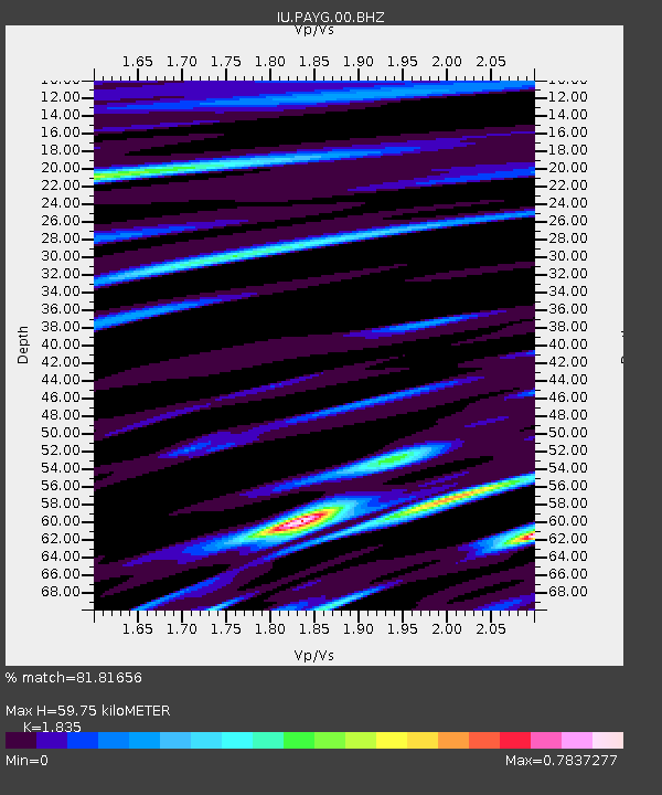
| Estimated Moho Depth: |
59.75 km |
| Estimated Crust Vp/Vs: |
1.84 |
| Assumed Crust Vp: |
4.802 km/s |
| Estimated Crust Vs: |
2.617 km/s |
| Estimated Crust Poisson's Ratio: |
0.29 |
|
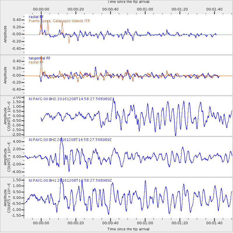
| Radial Match: |
81.81656 % |
| Radial Bump: |
400 |
| Transverse Match: |
67.01902 % |
| Transverse Bump: |
400 |
| SOD ConfigId: |
1894071 |
| Insert Time: |
2016-12-22 14:51:55.444 +0000 |
| GWidth: |
2.5 |
| Max Bumps: |
400 |
| Tol: |
0.001 |
|
Signal To Noise
| Channel | StoN | STA | LTA |
| IU:PAYG:00:BHZ:20161208T14:58:27.568989Z | 2.144297 | 7.87862E-7 | 3.6742207E-7 |
| IU:PAYG:00:BH1:20161208T14:58:27.568989Z | 0.650168 | 2.1349688E-7 | 3.2837184E-7 |
| IU:PAYG:00:BH2:20161208T14:58:27.568989Z | 1.8975825 | 4.5467158E-7 | 2.396057E-7 |
| Arrivals |
| Ps | 11 SECOND |
| PpPs | 34 SECOND |
| PsPs/PpSs | 45 SECOND |


