You are here: Home > Network List > IU - Global Seismograph Network (GSN - IRIS/USGS) Stations List
> Station SAML Samuel, Brazil > Earthquake Result Viewer
SAML Samuel, Brazil - Earthquake Result Viewer
| Earthquake location: |
Off Coast Of Northern California |
| Earthquake latitude/longitude: |
40.5/-126.2 |
| Earthquake time(UTC): |
2016/12/08 (343) 14:49:46 GMT |
| Earthquake Depth: |
12 km |
| Earthquake Magnitude: |
6.5 Mwb |
| Earthquake Catalog/Contributor: |
NEIC PDE/us |
|
| Network: |
IU Global Seismograph Network (GSN - IRIS/USGS) |
| Station: |
SAML Samuel, Brazil |
| Lat/Lon: |
8.95 S/63.18 W |
| Elevation: |
120 m |
|
| Distance: |
76.0 deg |
| Az: |
114.884 deg |
| Baz: |
315.539 deg |
| Ray Param: |
0.051312033 |
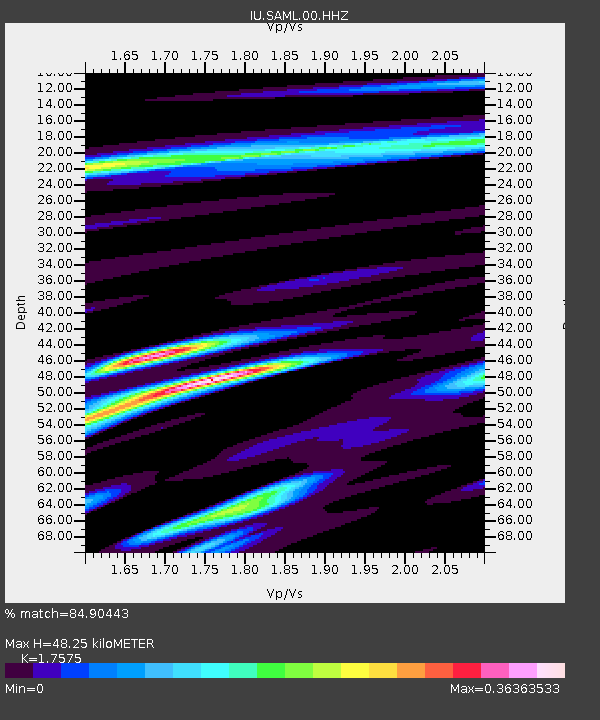
| Estimated Moho Depth: |
48.25 km |
| Estimated Crust Vp/Vs: |
1.76 |
| Assumed Crust Vp: |
6.498 km/s |
| Estimated Crust Vs: |
3.697 km/s |
| Estimated Crust Poisson's Ratio: |
0.26 |
|
| Radial Match: |
84.90443 % |
| Radial Bump: |
400 |
| Transverse Match: |
70.15389 % |
| Transverse Bump: |
400 |
| SOD ConfigId: |
1894071 |
| Insert Time: |
2016-12-22 14:52:02.821 +0000 |
| GWidth: |
2.5 |
| Max Bumps: |
400 |
| Tol: |
0.001 |
|

Signal To Noise
| Channel | StoN | STA | LTA |
| IU:SAML:00:HHZ:20161208T15:01:02.027974Z | 4.801221 | 4.169237E-7 | 8.683702E-8 |
| IU:SAML:00:HH1:20161208T15:01:02.027974Z | 1.9587197 | 2.015601E-7 | 1.02904E-7 |
| IU:SAML:00:HH2:20161208T15:01:02.027974Z | 0.79068047 | 6.284524E-8 | 7.9482476E-8 |
| Arrivals |
| Ps | 5.8 SECOND |
| PpPs | 20 SECOND |
| PsPs/PpSs | 26 SECOND |


