You are here: Home > Network List > TA - USArray Transportable Network (new EarthScope stations) Stations List
> Station G31M Satah River, YT, CAN > Earthquake Result Viewer
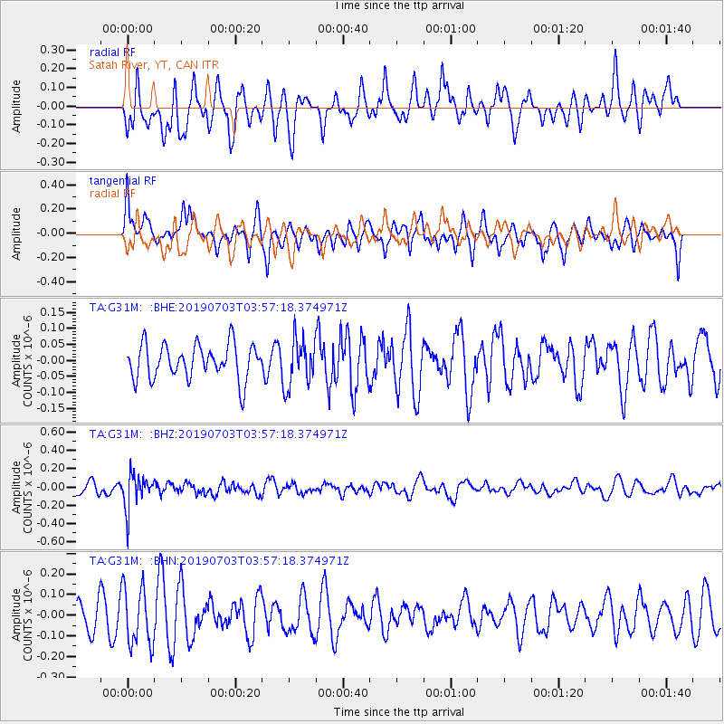
G31M Satah River, YT, CAN - Earthquake Result Viewer
*The percent match for this event was below the threshold and hence no stack was calculated.
| Earthquake location: |
South Of Fiji Islands |
| Earthquake latitude/longitude: |
-22.2/-179.5 |
| Earthquake time(UTC): |
2019/07/03 (184) 03:45:28 GMT |
| Earthquake Depth: |
574 km |
| Earthquake Magnitude: |
5.8 Mww |
| Earthquake Catalog/Contributor: |
NEIC PDE/us |
|
| Network: |
TA USArray Transportable Network (new EarthScope stations) |
| Station: |
G31M Satah River, YT, CAN |
| Lat/Lon: |
66.92 N/134.27 W |
| Elevation: |
61 m |
|
| Distance: |
95.0 deg |
| Az: |
16.316 deg |
| Baz: |
221.344 deg |
| Ray Param: |
$rayparam |
*The percent match for this event was below the threshold and hence was not used in the summary stack. |
|
| Radial Match: |
59.360455 % |
| Radial Bump: |
400 |
| Transverse Match: |
49.04613 % |
| Transverse Bump: |
400 |
| SOD ConfigId: |
19053131 |
| Insert Time: |
2019-07-17 03:52:04.777 +0000 |
| GWidth: |
2.5 |
| Max Bumps: |
400 |
| Tol: |
0.001 |
|
Signal To Noise
| Channel | StoN | STA | LTA |
| TA:G31M: :BHZ:20190703T03:57:18.374971Z | 2.9270785 | 1.84331E-7 | 6.2974394E-8 |
| TA:G31M: :BHN:20190703T03:57:18.374971Z | 2.4131966 | 1.4066451E-7 | 5.8289704E-8 |
| TA:G31M: :BHE:20190703T03:57:18.374971Z | 1.3688345 | 7.4006216E-8 | 5.4065133E-8 |
| Arrivals |
| Ps | |
| PpPs | |
| PsPs/PpSs | |


