You are here: Home > Network List > G - GEOSCOPE Stations List
> Station AIS New Amsterdam, Indian Ocean > Earthquake Result Viewer
AIS New Amsterdam, Indian Ocean - Earthquake Result Viewer

| Earthquake location: |
Solomon Islands |
| Earthquake latitude/longitude: |
-10.7/161.3 |
| Earthquake time(UTC): |
2016/12/08 (343) 17:38:46 GMT |
| Earthquake Depth: |
41 km |
| Earthquake Magnitude: |
7.8 mww |
| Earthquake Catalog/Contributor: |
NEIC PDE/us |
|
| Network: |
G GEOSCOPE |
| Station: |
AIS New Amsterdam, Indian Ocean |
| Lat/Lon: |
37.80 S/77.57 E |
| Elevation: |
35 m |
|
| Distance: |
78.6 deg |
| Az: |
233.438 deg |
| Baz: |
94.716 deg |
| Ray Param: |
0.04943774 |
| Estimated Moho Depth: |
32.0 km |
| Estimated Crust Vp/Vs: |
1.98 |
| Assumed Crust Vp: |
4.802 km/s |
| Estimated Crust Vs: |
2.425 km/s |
| Estimated Crust Poisson's Ratio: |
0.33 |
|
| Radial Match: |
93.21263 % |
| Radial Bump: |
400 |
| Transverse Match: |
72.38574 % |
| Transverse Bump: |
400 |
| SOD ConfigId: |
1894071 |
| Insert Time: |
2016-12-22 17:39:44.899 +0000 |
| GWidth: |
2.5 |
| Max Bumps: |
400 |
| Tol: |
0.001 |
|
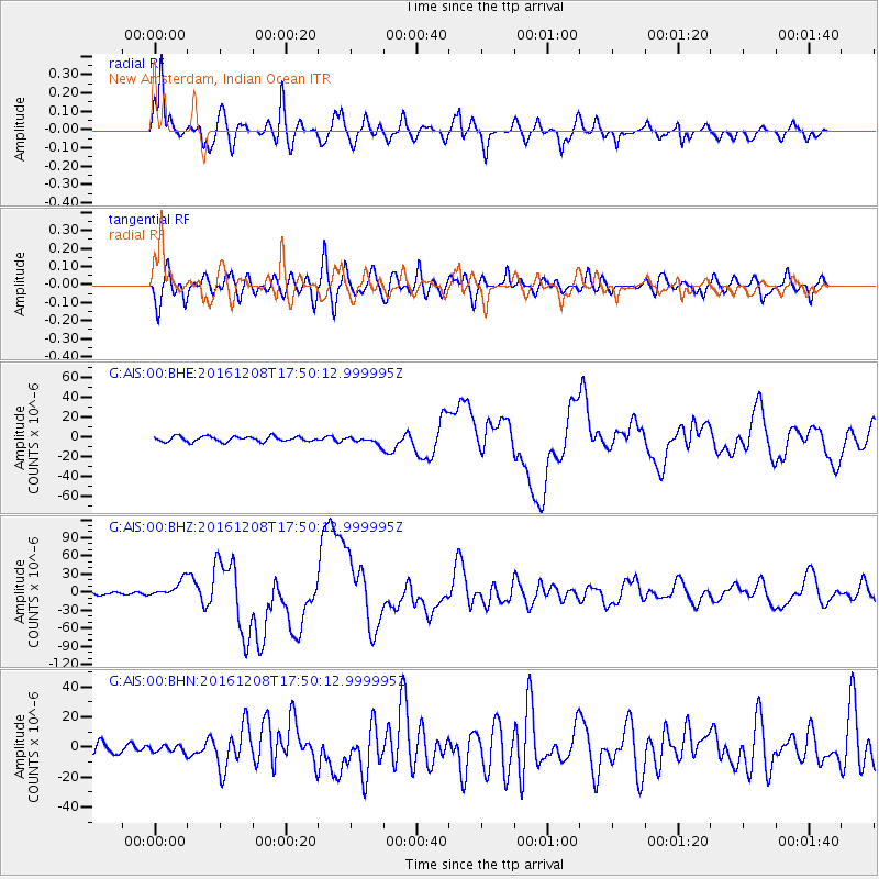
Signal To Noise
| Channel | StoN | STA | LTA |
| G:AIS:00:BHZ:20161208T17:50:12.999995Z | 7.966373 | 1.431596E-5 | 1.7970486E-6 |
| G:AIS:00:BHN:20161208T17:50:12.999995Z | 0.76183665 | 2.2275249E-6 | 2.923888E-6 |
| G:AIS:00:BHE:20161208T17:50:12.999995Z | 1.3577315 | 3.5934288E-6 | 2.6466419E-6 |
| Arrivals |
| Ps | 6.6 SECOND |
| PpPs | 20 SECOND |
| PsPs/PpSs | 26 SECOND |


