You are here: Home > Network List > TA - USArray Transportable Network (new EarthScope stations) Stations List
> Station B18K Kokolik River, AK, USA > Earthquake Result Viewer
B18K Kokolik River, AK, USA - Earthquake Result Viewer
*The percent match for this event was below the threshold and hence no stack was calculated.
| Earthquake location: |
Sichuan, China |
| Earthquake latitude/longitude: |
28.5/104.9 |
| Earthquake time(UTC): |
2019/07/04 (185) 02:17:58 GMT |
| Earthquake Depth: |
10 km |
| Earthquake Magnitude: |
5.2 Mww |
| Earthquake Catalog/Contributor: |
NEIC PDE/us |
|
| Network: |
TA USArray Transportable Network (new EarthScope stations) |
| Station: |
B18K Kokolik River, AK, USA |
| Lat/Lon: |
69.36 N/161.80 W |
| Elevation: |
222 m |
|
| Distance: |
64.8 deg |
| Az: |
23.026 deg |
| Baz: |
283.827 deg |
| Ray Param: |
$rayparam |
*The percent match for this event was below the threshold and hence was not used in the summary stack. |
|
| Radial Match: |
46.309307 % |
| Radial Bump: |
400 |
| Transverse Match: |
67.05605 % |
| Transverse Bump: |
400 |
| SOD ConfigId: |
19053131 |
| Insert Time: |
2019-07-18 02:22:28.259 +0000 |
| GWidth: |
2.5 |
| Max Bumps: |
400 |
| Tol: |
0.001 |
|
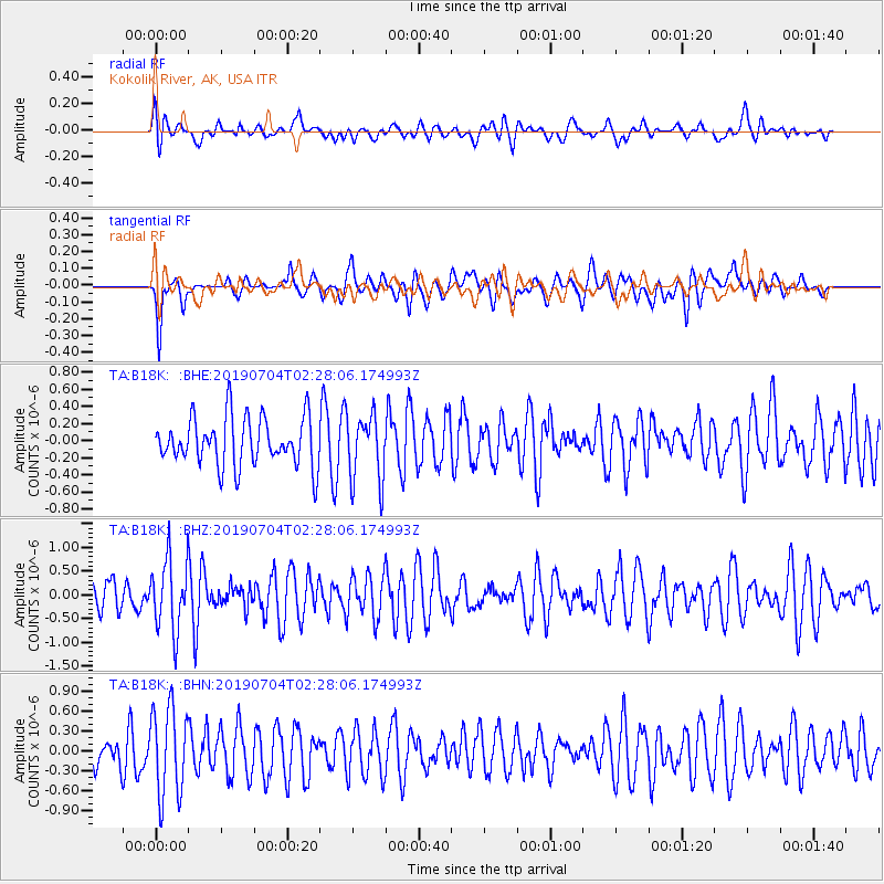
Signal To Noise
| Channel | StoN | STA | LTA |
| TA:B18K: :BHZ:20190704T02:28:06.174993Z | 2.1105518 | 7.5658045E-7 | 3.5847518E-7 |
| TA:B18K: :BHN:20190704T02:28:06.174993Z | 2.4178543 | 6.641074E-7 | 2.7466808E-7 |
| TA:B18K: :BHE:20190704T02:28:06.174993Z | 1.3769543 | 3.8860392E-7 | 2.822199E-7 |
| Arrivals |
| Ps | |
| PpPs | |
| PsPs/PpSs | |


