You are here: Home > Network List > G - GEOSCOPE Stations List
> Station CRZF Port Alfred, Crozet, South Indian Ocean > Earthquake Result Viewer
CRZF Port Alfred, Crozet, South Indian Ocean - Earthquake Result Viewer
| Earthquake location: |
Solomon Islands |
| Earthquake latitude/longitude: |
-10.7/161.3 |
| Earthquake time(UTC): |
2016/12/08 (343) 17:38:46 GMT |
| Earthquake Depth: |
41 km |
| Earthquake Magnitude: |
7.8 mww |
| Earthquake Catalog/Contributor: |
NEIC PDE/us |
|
| Network: |
G GEOSCOPE |
| Station: |
CRZF Port Alfred, Crozet, South Indian Ocean |
| Lat/Lon: |
46.43 S/51.86 E |
| Elevation: |
140 m |
|
| Distance: |
95.4 deg |
| Az: |
220.92 deg |
| Baz: |
111.439 deg |
| Ray Param: |
0.040778454 |
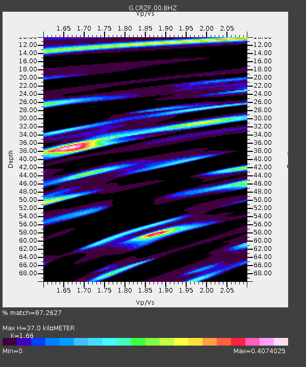
| Estimated Moho Depth: |
37.0 km |
| Estimated Crust Vp/Vs: |
1.66 |
| Assumed Crust Vp: |
4.802 km/s |
| Estimated Crust Vs: |
2.893 km/s |
| Estimated Crust Poisson's Ratio: |
0.22 |
|
| Radial Match: |
97.2627 % |
| Radial Bump: |
378 |
| Transverse Match: |
79.14902 % |
| Transverse Bump: |
400 |
| SOD ConfigId: |
1894071 |
| Insert Time: |
2016-12-22 17:39:48.499 +0000 |
| GWidth: |
2.5 |
| Max Bumps: |
400 |
| Tol: |
0.001 |
|
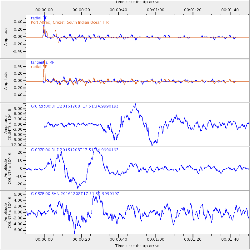
Signal To Noise
| Channel | StoN | STA | LTA |
| G:CRZF:00:BHZ:20161208T17:51:34.999019Z | 7.2362084 | 6.0006273E-6 | 8.292502E-7 |
| G:CRZF:00:BHN:20161208T17:51:34.999019Z | 2.2664104 | 1.188628E-6 | 5.24454E-7 |
| G:CRZF:00:BHE:20161208T17:51:34.999019Z | 3.6231182 | 2.3672103E-6 | 6.5336275E-7 |
| Arrivals |
| Ps | 5.1 SECOND |
| PpPs | 20 SECOND |
| PsPs/PpSs | 25 SECOND |


