You are here: Home > Network List > G - GEOSCOPE Stations List
> Station ROCAM Leguat Reserve, Rodrigues Island, Republic of Mauritius > Earthquake Result Viewer
ROCAM Leguat Reserve, Rodrigues Island, Republic of Mauritius - Earthquake Result Viewer
| Earthquake location: |
Solomon Islands |
| Earthquake latitude/longitude: |
-10.7/161.3 |
| Earthquake time(UTC): |
2016/12/08 (343) 17:38:46 GMT |
| Earthquake Depth: |
41 km |
| Earthquake Magnitude: |
7.8 mww |
| Earthquake Catalog/Contributor: |
NEIC PDE/us |
|
| Network: |
G GEOSCOPE |
| Station: |
ROCAM Leguat Reserve, Rodrigues Island, Republic of Mauritius |
| Lat/Lon: |
19.76 S/63.37 E |
| Elevation: |
52 m |
|
| Distance: |
93.8 deg |
| Az: |
249.204 deg |
| Baz: |
102.684 deg |
| Ray Param: |
0.04117142 |
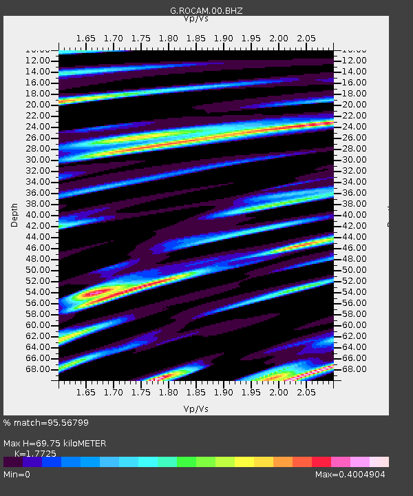
| Estimated Moho Depth: |
69.75 km |
| Estimated Crust Vp/Vs: |
1.77 |
| Assumed Crust Vp: |
4.802 km/s |
| Estimated Crust Vs: |
2.709 km/s |
| Estimated Crust Poisson's Ratio: |
0.27 |
|
| Radial Match: |
95.56799 % |
| Radial Bump: |
400 |
| Transverse Match: |
89.479256 % |
| Transverse Bump: |
400 |
| SOD ConfigId: |
1894071 |
| Insert Time: |
2016-12-22 17:39:55.030 +0000 |
| GWidth: |
2.5 |
| Max Bumps: |
400 |
| Tol: |
0.001 |
|

Signal To Noise
| Channel | StoN | STA | LTA |
| G:ROCAM:00:BHZ:20161208T17:51:27.848994Z | 5.951255 | 5.906331E-6 | 9.924513E-7 |
| G:ROCAM:00:BHN:20161208T17:51:27.848994Z | 1.3011383 | 8.369453E-7 | 6.432408E-7 |
| G:ROCAM:00:BHE:20161208T17:51:27.848994Z | 1.9095836 | 1.7637361E-6 | 9.236235E-7 |
| Arrivals |
| Ps | 11 SECOND |
| PpPs | 40 SECOND |
| PsPs/PpSs | 51 SECOND |


