You are here: Home > Network List > IU - Global Seismograph Network (GSN - IRIS/USGS) Stations List
> Station MAKZ Makanchi, Kazakhstan > Earthquake Result Viewer
MAKZ Makanchi, Kazakhstan - Earthquake Result Viewer
| Earthquake location: |
Solomon Islands |
| Earthquake latitude/longitude: |
-10.7/161.3 |
| Earthquake time(UTC): |
2016/12/08 (343) 17:38:46 GMT |
| Earthquake Depth: |
41 km |
| Earthquake Magnitude: |
7.8 mww |
| Earthquake Catalog/Contributor: |
NEIC PDE/us |
|
| Network: |
IU Global Seismograph Network (GSN - IRIS/USGS) |
| Station: |
MAKZ Makanchi, Kazakhstan |
| Lat/Lon: |
46.81 N/81.98 E |
| Elevation: |
600 m |
|
| Distance: |
90.5 deg |
| Az: |
317.539 deg |
| Baz: |
104.976 deg |
| Ray Param: |
0.04166201 |
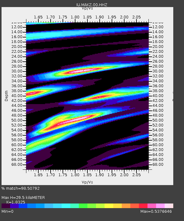
| Estimated Moho Depth: |
29.5 km |
| Estimated Crust Vp/Vs: |
1.83 |
| Assumed Crust Vp: |
6.571 km/s |
| Estimated Crust Vs: |
3.586 km/s |
| Estimated Crust Poisson's Ratio: |
0.29 |
|
| Radial Match: |
98.50792 % |
| Radial Bump: |
320 |
| Transverse Match: |
97.300606 % |
| Transverse Bump: |
353 |
| SOD ConfigId: |
1894071 |
| Insert Time: |
2016-12-22 17:40:33.770 +0000 |
| GWidth: |
2.5 |
| Max Bumps: |
400 |
| Tol: |
0.001 |
|

Signal To Noise
| Channel | StoN | STA | LTA |
| IU:MAKZ:00:HHZ:20161208T17:51:12.697993Z | 31.067062 | 6.0115403E-6 | 1.9350205E-7 |
| IU:MAKZ:00:HH1:20161208T17:51:12.697993Z | 7.0162063 | 3.97728E-7 | 5.6687043E-8 |
| IU:MAKZ:00:HH2:20161208T17:51:12.697993Z | 16.49575 | 1.7739211E-6 | 1.07538064E-7 |
| Arrivals |
| Ps | 3.8 SECOND |
| PpPs | 12 SECOND |
| PsPs/PpSs | 16 SECOND |


