You are here: Home > Network List > IU - Global Seismograph Network (GSN - IRIS/USGS) Stations List
> Station RAR Rarotonga, Cook Islands > Earthquake Result Viewer
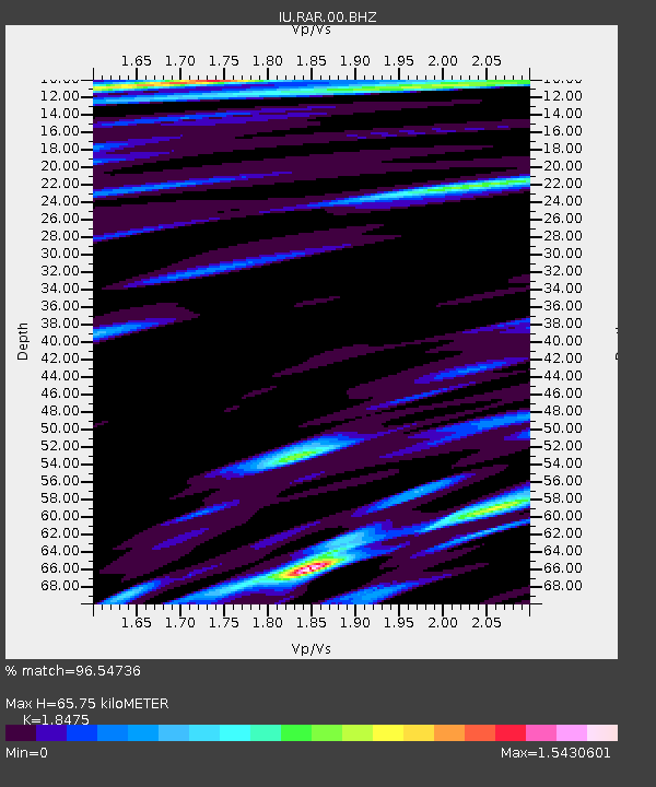
RAR Rarotonga, Cook Islands - Earthquake Result Viewer
| Earthquake location: |
Solomon Islands |
| Earthquake latitude/longitude: |
-10.7/161.3 |
| Earthquake time(UTC): |
2016/12/08 (343) 17:38:46 GMT |
| Earthquake Depth: |
41 km |
| Earthquake Magnitude: |
7.8 mww |
| Earthquake Catalog/Contributor: |
NEIC PDE/us |
|
| Network: |
IU Global Seismograph Network (GSN - IRIS/USGS) |
| Station: |
RAR Rarotonga, Cook Islands |
| Lat/Lon: |
21.21 S/159.77 W |
| Elevation: |
28 m |
|
| Distance: |
38.7 deg |
| Az: |
110.574 deg |
| Baz: |
279.514 deg |
| Ray Param: |
0.07529322 |
| Estimated Moho Depth: |
65.75 km |
| Estimated Crust Vp/Vs: |
1.85 |
| Assumed Crust Vp: |
4.24 km/s |
| Estimated Crust Vs: |
2.295 km/s |
| Estimated Crust Poisson's Ratio: |
0.29 |
|
| Radial Match: |
96.54736 % |
| Radial Bump: |
338 |
| Transverse Match: |
84.131004 % |
| Transverse Bump: |
400 |
| SOD ConfigId: |
1894071 |
| Insert Time: |
2016-12-22 17:40:43.415 +0000 |
| GWidth: |
2.5 |
| Max Bumps: |
400 |
| Tol: |
0.001 |
|

Signal To Noise
| Channel | StoN | STA | LTA |
| IU:RAR:00:BHZ:20161208T17:45:36.269008Z | 15.385298 | 4.0534454E-5 | 2.6346224E-6 |
| IU:RAR:00:BH1:20161208T17:45:36.269008Z | 4.771739 | 1.5478814E-5 | 3.2438516E-6 |
| IU:RAR:00:BH2:20161208T17:45:36.269008Z | 20.488712 | 3.2472057E-5 | 1.5848753E-6 |
| Arrivals |
| Ps | 14 SECOND |
| PpPs | 43 SECOND |
| PsPs/PpSs | 56 SECOND |


