You are here: Home > Network List > MU - Miami University Seismic Network Stations List
> Station MUB2 Belmont > Earthquake Result Viewer
MUB2 Belmont - Earthquake Result Viewer
| Earthquake location: |
Queen Charlotte Islands Region |
| Earthquake latitude/longitude: |
51.2/-130.5 |
| Earthquake time(UTC): |
2019/07/04 (185) 04:30:44 GMT |
| Earthquake Depth: |
10 km |
| Earthquake Magnitude: |
6.2 Mww |
| Earthquake Catalog/Contributor: |
NEIC PDE/us |
|
| Network: |
MU Miami University Seismic Network |
| Station: |
MUB2 Belmont |
| Lat/Lon: |
40.08 N/80.90 W |
| Elevation: |
384 m |
|
| Distance: |
35.8 deg |
| Az: |
88.351 deg |
| Baz: |
304.984 deg |
| Ray Param: |
0.07704013 |
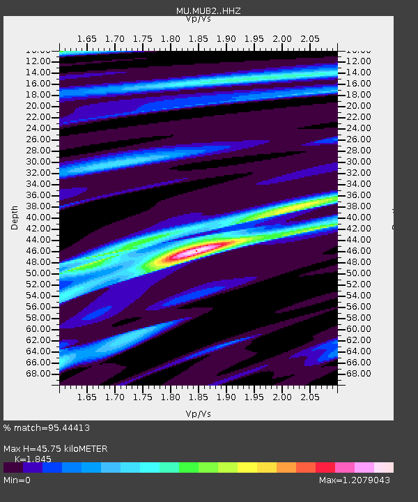
| Estimated Moho Depth: |
45.75 km |
| Estimated Crust Vp/Vs: |
1.85 |
| Assumed Crust Vp: |
6.483 km/s |
| Estimated Crust Vs: |
3.514 km/s |
| Estimated Crust Poisson's Ratio: |
0.29 |
|
| Radial Match: |
95.44413 % |
| Radial Bump: |
253 |
| Transverse Match: |
61.10317 % |
| Transverse Bump: |
400 |
| SOD ConfigId: |
19053131 |
| Insert Time: |
2019-07-18 04:34:19.691 +0000 |
| GWidth: |
2.5 |
| Max Bumps: |
400 |
| Tol: |
0.001 |
|

Signal To Noise
| Channel | StoN | STA | LTA |
| MU:MUB2: :HHZ:20190704T04:37:12.669986Z | 4.764572 | 2.6889193E-6 | 5.643569E-7 |
| MU:MUB2: :HHN:20190704T04:37:12.669986Z | 2.0180645 | 1.3368946E-6 | 6.624638E-7 |
| MU:MUB2: :HHE:20190704T04:37:12.669986Z | 1.5460969 | 8.337207E-7 | 5.392422E-7 |
| Arrivals |
| Ps | 6.4 SECOND |
| PpPs | 19 SECOND |
| PsPs/PpSs | 25 SECOND |


