You are here: Home > Network List > MX - Mexican National Seismic Network Stations List
> Station MOIG Morelia, Mich, MX > Earthquake Result Viewer
MOIG Morelia, Mich, MX - Earthquake Result Viewer
| Earthquake location: |
Queen Charlotte Islands Region |
| Earthquake latitude/longitude: |
51.2/-130.5 |
| Earthquake time(UTC): |
2019/07/04 (185) 04:30:44 GMT |
| Earthquake Depth: |
10 km |
| Earthquake Magnitude: |
6.2 Mww |
| Earthquake Catalog/Contributor: |
NEIC PDE/us |
|
| Network: |
MX Mexican National Seismic Network |
| Station: |
MOIG Morelia, Mich, MX |
| Lat/Lon: |
19.65 N/101.23 W |
| Elevation: |
2000 m |
|
| Distance: |
39.0 deg |
| Az: |
132.934 deg |
| Baz: |
330.757 deg |
| Ray Param: |
0.07521916 |
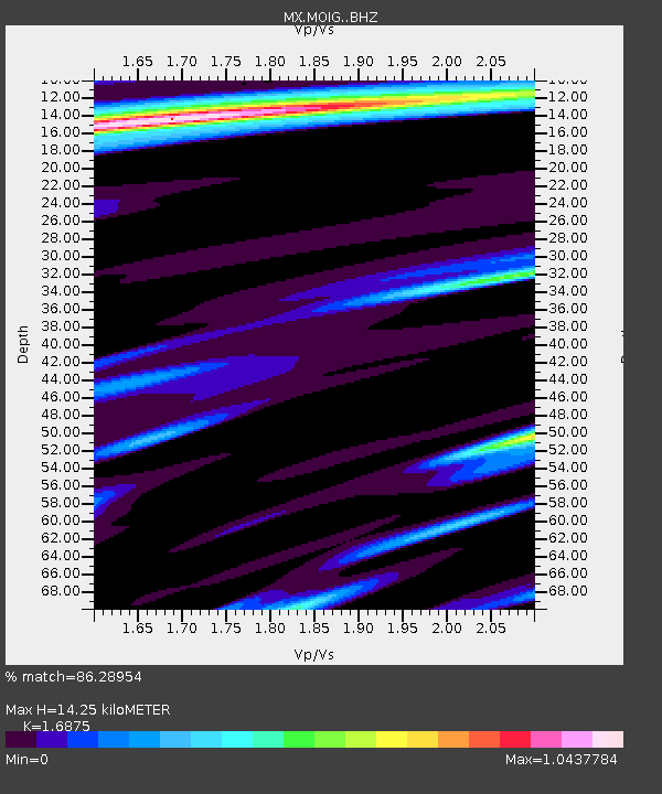
| Estimated Moho Depth: |
14.25 km |
| Estimated Crust Vp/Vs: |
1.69 |
| Assumed Crust Vp: |
6.566 km/s |
| Estimated Crust Vs: |
3.891 km/s |
| Estimated Crust Poisson's Ratio: |
0.23 |
|
| Radial Match: |
86.28954 % |
| Radial Bump: |
400 |
| Transverse Match: |
71.03741 % |
| Transverse Bump: |
400 |
| SOD ConfigId: |
19053131 |
| Insert Time: |
2019-07-18 04:34:22.590 +0000 |
| GWidth: |
2.5 |
| Max Bumps: |
400 |
| Tol: |
0.001 |
|

Signal To Noise
| Channel | StoN | STA | LTA |
| MX:MOIG: :BHZ:20190704T04:37:40.19501Z | 8.619736 | 1.3695018E-6 | 1.5887979E-7 |
| MX:MOIG: :BHN:20190704T04:37:40.19501Z | 1.8686161 | 5.2438725E-7 | 2.8062865E-7 |
| MX:MOIG: :BHE:20190704T04:37:40.19501Z | 1.9054413 | 3.2363454E-7 | 1.6984755E-7 |
| Arrivals |
| Ps | 1.6 SECOND |
| PpPs | 5.4 SECOND |
| PsPs/PpSs | 7.0 SECOND |


