You are here: Home > Network List > N4 - Central and EAstern US Network Stations List
> Station M50A Fremont, OH, USA > Earthquake Result Viewer
M50A Fremont, OH, USA - Earthquake Result Viewer
| Earthquake location: |
Queen Charlotte Islands Region |
| Earthquake latitude/longitude: |
51.2/-130.5 |
| Earthquake time(UTC): |
2019/07/04 (185) 04:30:44 GMT |
| Earthquake Depth: |
10 km |
| Earthquake Magnitude: |
6.2 Mww |
| Earthquake Catalog/Contributor: |
NEIC PDE/us |
|
| Network: |
N4 Central and EAstern US Network |
| Station: |
M50A Fremont, OH, USA |
| Lat/Lon: |
41.40 N/83.04 W |
| Elevation: |
176 m |
|
| Distance: |
33.7 deg |
| Az: |
88.04 deg |
| Baz: |
303.335 deg |
| Ray Param: |
0.07809121 |
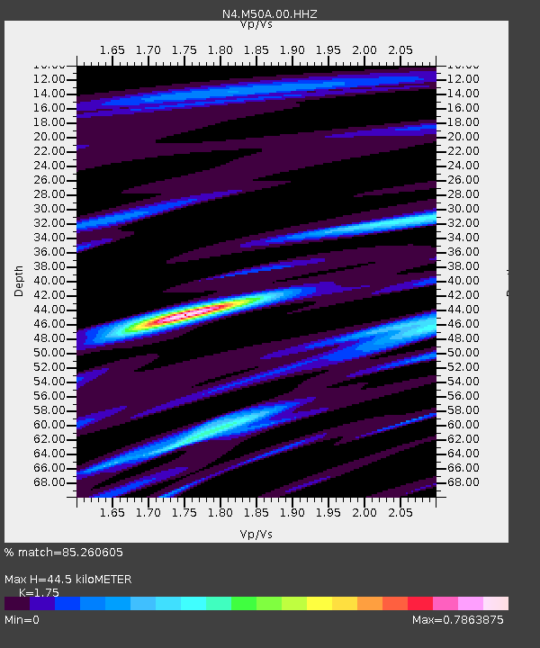
| Estimated Moho Depth: |
44.5 km |
| Estimated Crust Vp/Vs: |
1.75 |
| Assumed Crust Vp: |
6.498 km/s |
| Estimated Crust Vs: |
3.713 km/s |
| Estimated Crust Poisson's Ratio: |
0.26 |
|
| Radial Match: |
85.260605 % |
| Radial Bump: |
300 |
| Transverse Match: |
74.82887 % |
| Transverse Bump: |
400 |
| SOD ConfigId: |
19053131 |
| Insert Time: |
2019-07-18 04:34:41.462 +0000 |
| GWidth: |
2.5 |
| Max Bumps: |
400 |
| Tol: |
0.001 |
|

Signal To Noise
| Channel | StoN | STA | LTA |
| N4:M50A:00:HHZ:20190704T04:36:54.679996Z | 5.4246893 | 7.61712E-7 | 1.4041579E-7 |
| N4:M50A:00:HH1:20190704T04:36:54.679996Z | 2.009139 | 3.4502463E-7 | 1.7172759E-7 |
| N4:M50A:00:HH2:20190704T04:36:54.679996Z | 2.6630247 | 4.2005036E-7 | 1.5773432E-7 |
| Arrivals |
| Ps | 5.6 SECOND |
| PpPs | 17 SECOND |
| PsPs/PpSs | 23 SECOND |


