You are here: Home > Network List > N4 - Central and EAstern US Network Stations List
> Station R58B Mineral, VA, USA > Earthquake Result Viewer
R58B Mineral, VA, USA - Earthquake Result Viewer
| Earthquake location: |
Queen Charlotte Islands Region |
| Earthquake latitude/longitude: |
51.2/-130.5 |
| Earthquake time(UTC): |
2019/07/04 (185) 04:30:44 GMT |
| Earthquake Depth: |
10 km |
| Earthquake Magnitude: |
6.2 Mww |
| Earthquake Catalog/Contributor: |
NEIC PDE/us |
|
| Network: |
N4 Central and EAstern US Network |
| Station: |
R58B Mineral, VA, USA |
| Lat/Lon: |
37.96 N/77.88 W |
| Elevation: |
116 m |
|
| Distance: |
38.9 deg |
| Az: |
88.88 deg |
| Baz: |
307.3 deg |
| Ray Param: |
0.07527943 |
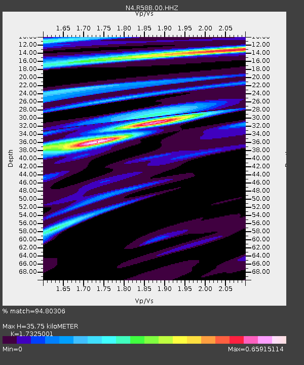
| Estimated Moho Depth: |
35.75 km |
| Estimated Crust Vp/Vs: |
1.73 |
| Assumed Crust Vp: |
6.565 km/s |
| Estimated Crust Vs: |
3.789 km/s |
| Estimated Crust Poisson's Ratio: |
0.25 |
|
| Radial Match: |
94.80306 % |
| Radial Bump: |
207 |
| Transverse Match: |
72.89224 % |
| Transverse Bump: |
400 |
| SOD ConfigId: |
19053131 |
| Insert Time: |
2019-07-18 04:34:56.230 +0000 |
| GWidth: |
2.5 |
| Max Bumps: |
400 |
| Tol: |
0.001 |
|

Signal To Noise
| Channel | StoN | STA | LTA |
| N4:R58B:00:HHZ:20190704T04:37:39.32001Z | 8.581477 | 9.574311E-7 | 1.1156949E-7 |
| N4:R58B:00:HH1:20190704T04:37:39.32001Z | 3.8674247 | 3.9669658E-7 | 1.0257383E-7 |
| N4:R58B:00:HH2:20190704T04:37:39.32001Z | 6.075638 | 4.7535977E-7 | 7.824031E-8 |
| Arrivals |
| Ps | 4.3 SECOND |
| PpPs | 14 SECOND |
| PsPs/PpSs | 18 SECOND |


