You are here: Home > Network List > N4 - Central and EAstern US Network Stations List
> Station W59A Clinton, NC, USA > Earthquake Result Viewer
W59A Clinton, NC, USA - Earthquake Result Viewer
| Earthquake location: |
Queen Charlotte Islands Region |
| Earthquake latitude/longitude: |
51.2/-130.5 |
| Earthquake time(UTC): |
2019/07/04 (185) 04:30:44 GMT |
| Earthquake Depth: |
10 km |
| Earthquake Magnitude: |
6.2 Mww |
| Earthquake Catalog/Contributor: |
NEIC PDE/us |
|
| Network: |
N4 Central and EAstern US Network |
| Station: |
W59A Clinton, NC, USA |
| Lat/Lon: |
35.17 N/78.44 W |
| Elevation: |
60 m |
|
| Distance: |
40.3 deg |
| Az: |
92.744 deg |
| Baz: |
309.942 deg |
| Ray Param: |
0.074468866 |
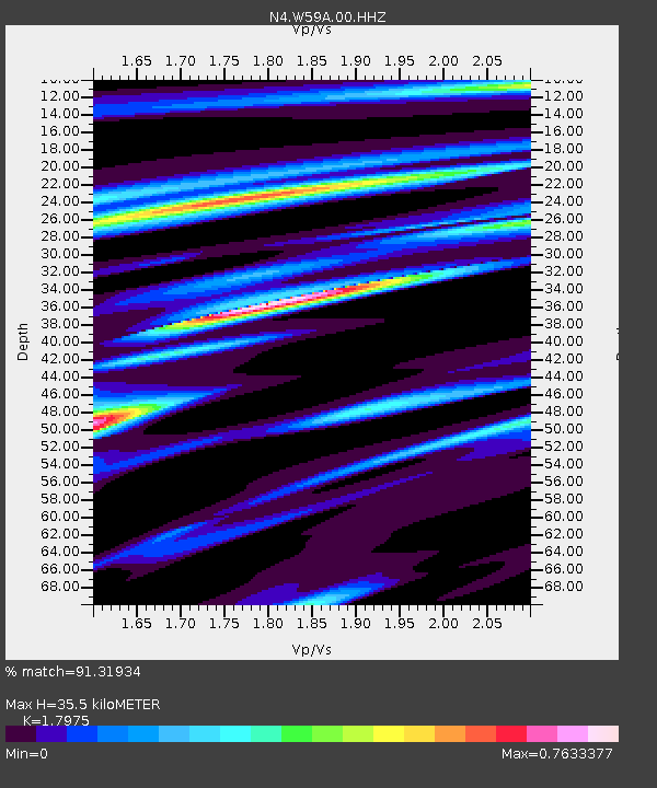
| Estimated Moho Depth: |
35.5 km |
| Estimated Crust Vp/Vs: |
1.80 |
| Assumed Crust Vp: |
6.565 km/s |
| Estimated Crust Vs: |
3.652 km/s |
| Estimated Crust Poisson's Ratio: |
0.28 |
|
| Radial Match: |
91.31934 % |
| Radial Bump: |
306 |
| Transverse Match: |
58.703644 % |
| Transverse Bump: |
400 |
| SOD ConfigId: |
19053131 |
| Insert Time: |
2019-07-18 04:35:08.333 +0000 |
| GWidth: |
2.5 |
| Max Bumps: |
400 |
| Tol: |
0.001 |
|

Signal To Noise
| Channel | StoN | STA | LTA |
| N4:W59A:00:HHZ:20190704T04:37:50.859012Z | 7.927847 | 1.0197135E-6 | 1.2862428E-7 |
| N4:W59A:00:HH1:20190704T04:37:50.859012Z | 4.432997 | 5.0610123E-7 | 1.1416683E-7 |
| N4:W59A:00:HH2:20190704T04:37:50.859012Z | 5.636487 | 6.208088E-7 | 1.1014109E-7 |
| Arrivals |
| Ps | 4.6 SECOND |
| PpPs | 14 SECOND |
| PsPs/PpSs | 19 SECOND |


