You are here: Home > Network List > NM - Cooperative New Madrid Seismic Network Stations List
> Station HDAR2 I40 Weigh Station,West Memphis,AR > Earthquake Result Viewer
HDAR2 I40 Weigh Station,West Memphis,AR - Earthquake Result Viewer
| Earthquake location: |
Queen Charlotte Islands Region |
| Earthquake latitude/longitude: |
51.2/-130.5 |
| Earthquake time(UTC): |
2019/07/04 (185) 04:30:44 GMT |
| Earthquake Depth: |
10 km |
| Earthquake Magnitude: |
6.2 Mww |
| Earthquake Catalog/Contributor: |
NEIC PDE/us |
|
| Network: |
NM Cooperative New Madrid Seismic Network |
| Station: |
HDAR2 I40 Weigh Station,West Memphis,AR |
| Lat/Lon: |
35.15 N/90.09 W |
| Elevation: |
100 m |
|
| Distance: |
33.1 deg |
| Az: |
103.192 deg |
| Baz: |
311.652 deg |
| Ray Param: |
0.078374796 |
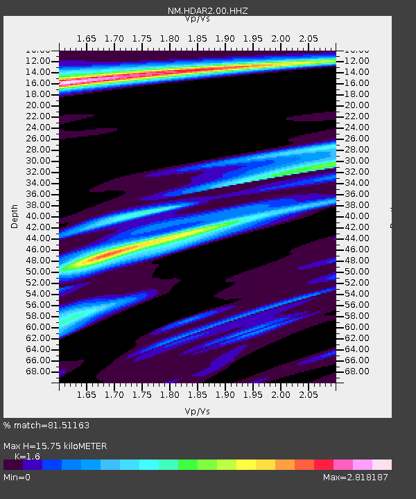
| Estimated Moho Depth: |
15.75 km |
| Estimated Crust Vp/Vs: |
1.60 |
| Assumed Crust Vp: |
6.273 km/s |
| Estimated Crust Vs: |
3.921 km/s |
| Estimated Crust Poisson's Ratio: |
0.18 |
|
| Radial Match: |
81.51163 % |
| Radial Bump: |
400 |
| Transverse Match: |
54.772537 % |
| Transverse Bump: |
400 |
| SOD ConfigId: |
19053131 |
| Insert Time: |
2019-07-18 04:35:24.474 +0000 |
| GWidth: |
2.5 |
| Max Bumps: |
400 |
| Tol: |
0.001 |
|
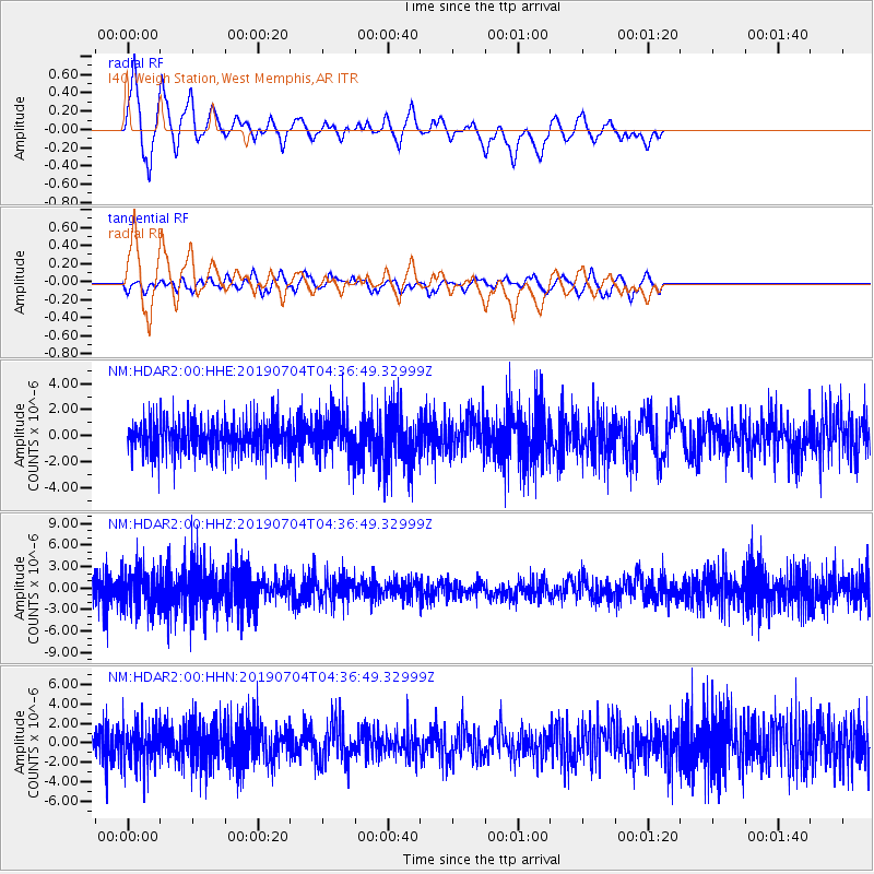
Signal To Noise
| Channel | StoN | STA | LTA |
| NM:HDAR2:00:HHZ:20190704T04:36:49.32999Z | 1.6385121 | 2.7302622E-6 | 1.6663058E-6 |
| NM:HDAR2:00:HHN:20190704T04:36:49.32999Z | 1.4458278 | 1.9892236E-6 | 1.3758372E-6 |
| NM:HDAR2:00:HHE:20190704T04:36:49.32999Z | 1.3292695 | 1.6716693E-6 | 1.2575849E-6 |
| Arrivals |
| Ps | 1.6 SECOND |
| PpPs | 6.0 SECOND |
| PsPs/PpSs | 7.6 SECOND |


