You are here: Home > Network List > PE - Penn State Network Stations List
> Station PAGS PA Geological Survey, Middletown, PA > Earthquake Result Viewer
PAGS PA Geological Survey, Middletown, PA - Earthquake Result Viewer
| Earthquake location: |
Queen Charlotte Islands Region |
| Earthquake latitude/longitude: |
51.2/-130.5 |
| Earthquake time(UTC): |
2019/07/04 (185) 04:30:44 GMT |
| Earthquake Depth: |
10 km |
| Earthquake Magnitude: |
6.2 Mww |
| Earthquake Catalog/Contributor: |
NEIC PDE/us |
|
| Network: |
PE Penn State Network |
| Station: |
PAGS PA Geological Survey, Middletown, PA |
| Lat/Lon: |
40.23 N/76.72 W |
| Elevation: |
120 m |
|
| Distance: |
38.3 deg |
| Az: |
85.1 deg |
| Baz: |
305.074 deg |
| Ray Param: |
0.07563105 |
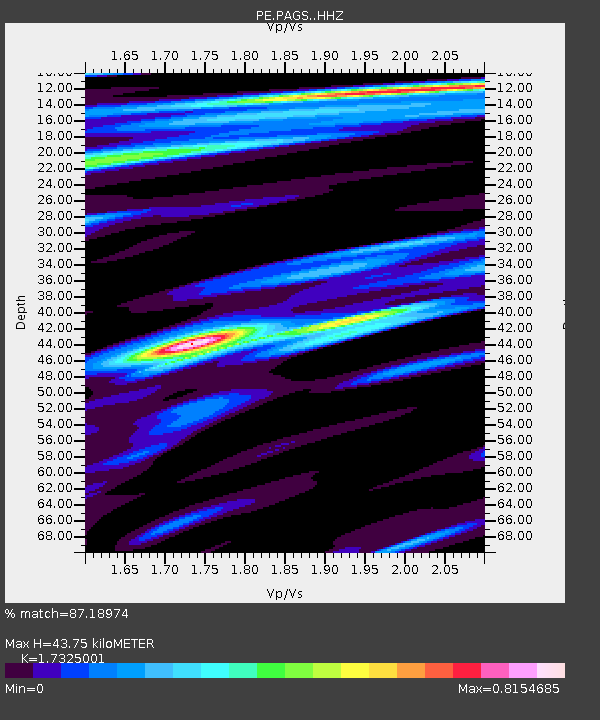
| Estimated Moho Depth: |
43.75 km |
| Estimated Crust Vp/Vs: |
1.73 |
| Assumed Crust Vp: |
6.121 km/s |
| Estimated Crust Vs: |
3.533 km/s |
| Estimated Crust Poisson's Ratio: |
0.25 |
|
| Radial Match: |
87.18974 % |
| Radial Bump: |
400 |
| Transverse Match: |
67.65683 % |
| Transverse Bump: |
400 |
| SOD ConfigId: |
19053131 |
| Insert Time: |
2019-07-18 04:35:54.981 +0000 |
| GWidth: |
2.5 |
| Max Bumps: |
400 |
| Tol: |
0.001 |
|
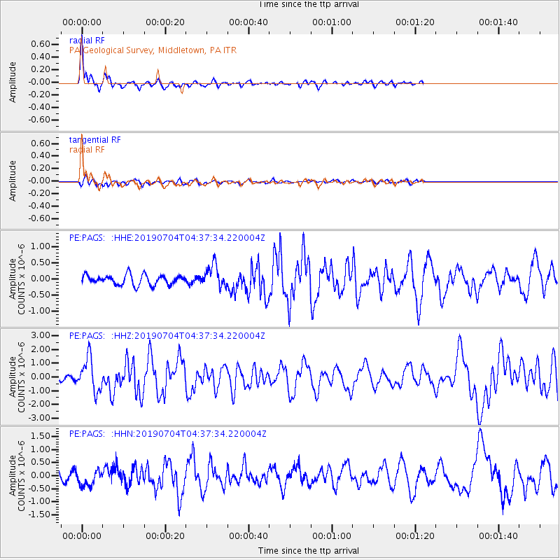
Signal To Noise
| Channel | StoN | STA | LTA |
| PE:PAGS: :HHZ:20190704T04:37:34.220004Z | 5.6523767 | 1.2260033E-6 | 2.1690049E-7 |
| PE:PAGS: :HHN:20190704T04:37:34.220004Z | 1.7401212 | 3.1227424E-7 | 1.7945544E-7 |
| PE:PAGS: :HHE:20190704T04:37:34.220004Z | 2.319135 | 3.5097108E-7 | 1.5133706E-7 |
| Arrivals |
| Ps | 5.6 SECOND |
| PpPs | 18 SECOND |
| PsPs/PpSs | 24 SECOND |


