You are here: Home > Network List > AT - Alaska Tsunami Warning Seismic System Stations List
> Station OHAK Old Harbor, Alaska > Earthquake Result Viewer
OHAK Old Harbor, Alaska - Earthquake Result Viewer
| Earthquake location: |
Central California |
| Earthquake latitude/longitude: |
35.7/-117.5 |
| Earthquake time(UTC): |
2019/07/04 (185) 17:33:49 GMT |
| Earthquake Depth: |
11 km |
| Earthquake Magnitude: |
6.4 mw |
| Earthquake Catalog/Contributor: |
NEIC PDE/ci |
|
| Network: |
AT Alaska Tsunami Warning Seismic System |
| Station: |
OHAK Old Harbor, Alaska |
| Lat/Lon: |
57.22 N/153.29 W |
| Elevation: |
78 m |
|
| Distance: |
32.1 deg |
| Az: |
323.291 deg |
| Baz: |
116.57 deg |
| Ray Param: |
0.07877486 |
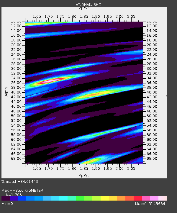
| Estimated Moho Depth: |
35.0 km |
| Estimated Crust Vp/Vs: |
1.71 |
| Assumed Crust Vp: |
6.134 km/s |
| Estimated Crust Vs: |
3.598 km/s |
| Estimated Crust Poisson's Ratio: |
0.24 |
|
| Radial Match: |
84.01443 % |
| Radial Bump: |
325 |
| Transverse Match: |
75.75871 % |
| Transverse Bump: |
400 |
| SOD ConfigId: |
19053131 |
| Insert Time: |
2019-07-18 17:35:17.317 +0000 |
| GWidth: |
2.5 |
| Max Bumps: |
400 |
| Tol: |
0.001 |
|

Signal To Noise
| Channel | StoN | STA | LTA |
| AT:OHAK: :BHZ:20190704T17:39:45.839988Z | 1.1808301 | 1.15246145E-7 | 9.7597564E-8 |
| AT:OHAK: :BHN:20190704T17:39:45.839988Z | 1.0914513 | 1.15432606E-7 | 1.05760655E-7 |
| AT:OHAK: :BHE:20190704T17:39:45.839988Z | 1.7467991 | 1.5823106E-7 | 9.0583434E-8 |
| Arrivals |
| Ps | 4.3 SECOND |
| PpPs | 14 SECOND |
| PsPs/PpSs | 19 SECOND |


