You are here: Home > Network List > IU - Global Seismograph Network (GSN - IRIS/USGS) Stations List
> Station SLBS Sierra la Laguna Baja California Sur, Mexico > Earthquake Result Viewer
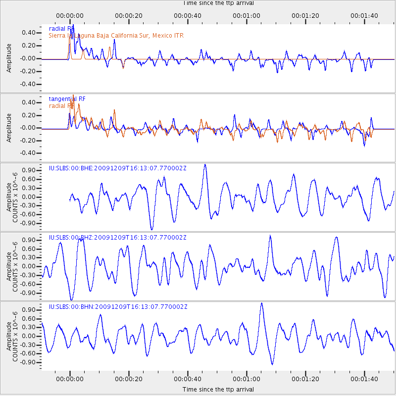
SLBS Sierra la Laguna Baja California Sur, Mexico - Earthquake Result Viewer
*The percent match for this event was below the threshold and hence no stack was calculated.
| Earthquake location: |
Central Mid-Atlantic Ridge |
| Earthquake latitude/longitude: |
-0.6/-21.1 |
| Earthquake time(UTC): |
2009/12/09 (343) 16:00:43 GMT |
| Earthquake Depth: |
10 km |
| Earthquake Magnitude: |
5.5 MB, 5.6 MS, 6.4 MW, 6.4 MW |
| Earthquake Catalog/Contributor: |
WHDF/NEIC |
|
| Network: |
IU Global Seismograph Network (GSN - IRIS/USGS) |
| Station: |
SLBS Sierra la Laguna Baja California Sur, Mexico |
| Lat/Lon: |
23.69 N/109.94 W |
| Elevation: |
825 m |
|
| Distance: |
89.2 deg |
| Az: |
293.558 deg |
| Baz: |
91.035 deg |
| Ray Param: |
$rayparam |
*The percent match for this event was below the threshold and hence was not used in the summary stack. |
|
| Radial Match: |
79.82424 % |
| Radial Bump: |
400 |
| Transverse Match: |
50.47404 % |
| Transverse Bump: |
400 |
| SOD ConfigId: |
1 |
| Insert Time: |
2010-02-19 01:20:52.562 +0000 |
| GWidth: |
2.5 |
| Max Bumps: |
400 |
| Tol: |
0.001 |
|
Signal To Noise
| Channel | StoN | STA | LTA |
| IU:SLBS:00:BHZ:20091209T16:13:07.770002Z | 3.979233 | 8.2669925E-7 | 2.077534E-7 |
| IU:SLBS:00:BHN:20091209T16:13:07.770002Z | 0.77464724 | 2.1406908E-7 | 2.7634394E-7 |
| IU:SLBS:00:BHE:20091209T16:13:07.770002Z | 1.8064941 | 4.350917E-7 | 2.4084866E-7 |
| Arrivals |
| Ps | |
| PpPs | |
| PsPs/PpSs | |


