You are here: Home > Network List > AT - Alaska Tsunami Warning Seismic System Stations List
> Station SDPT Sand Point, Alaska > Earthquake Result Viewer
SDPT Sand Point, Alaska - Earthquake Result Viewer
| Earthquake location: |
Central California |
| Earthquake latitude/longitude: |
35.7/-117.5 |
| Earthquake time(UTC): |
2019/07/04 (185) 17:33:49 GMT |
| Earthquake Depth: |
11 km |
| Earthquake Magnitude: |
6.4 mw |
| Earthquake Catalog/Contributor: |
NEIC PDE/ci |
|
| Network: |
AT Alaska Tsunami Warning Seismic System |
| Station: |
SDPT Sand Point, Alaska |
| Lat/Lon: |
55.35 N/160.48 W |
| Elevation: |
74 m |
|
| Distance: |
35.2 deg |
| Az: |
317.526 deg |
| Baz: |
105.799 deg |
| Ray Param: |
0.07734211 |
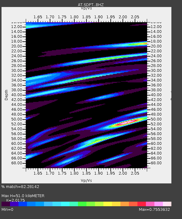
| Estimated Moho Depth: |
51.0 km |
| Estimated Crust Vp/Vs: |
2.02 |
| Assumed Crust Vp: |
5.989 km/s |
| Estimated Crust Vs: |
2.969 km/s |
| Estimated Crust Poisson's Ratio: |
0.34 |
|
| Radial Match: |
82.28142 % |
| Radial Bump: |
400 |
| Transverse Match: |
69.49159 % |
| Transverse Bump: |
400 |
| SOD ConfigId: |
19053131 |
| Insert Time: |
2019-07-18 17:35:17.551 +0000 |
| GWidth: |
2.5 |
| Max Bumps: |
400 |
| Tol: |
0.001 |
|

Signal To Noise
| Channel | StoN | STA | LTA |
| AT:SDPT: :BHZ:20190704T17:40:12.420005Z | 2.1065474 | 5.377177E-7 | 2.552602E-7 |
| AT:SDPT: :BHN:20190704T17:40:12.420005Z | 1.232576 | 2.44749E-7 | 1.9856707E-7 |
| AT:SDPT: :BHE:20190704T17:40:12.420005Z | 1.1534823 | 2.504072E-7 | 2.1708802E-7 |
| Arrivals |
| Ps | 9.2 SECOND |
| PpPs | 24 SECOND |
| PsPs/PpSs | 33 SECOND |


