You are here: Home > Network List > US - United States National Seismic Network Stations List
> Station RLMT Red Lodge, Montana, USA > Earthquake Result Viewer
RLMT Red Lodge, Montana, USA - Earthquake Result Viewer

| Earthquake location: |
Solomon Islands |
| Earthquake latitude/longitude: |
-10.7/161.3 |
| Earthquake time(UTC): |
2016/12/08 (343) 17:38:46 GMT |
| Earthquake Depth: |
41 km |
| Earthquake Magnitude: |
7.8 mww |
| Earthquake Catalog/Contributor: |
NEIC PDE/us |
|
| Network: |
US United States National Seismic Network |
| Station: |
RLMT Red Lodge, Montana, USA |
| Lat/Lon: |
45.12 N/109.27 W |
| Elevation: |
2086 m |
|
| Distance: |
97.1 deg |
| Az: |
45.506 deg |
| Baz: |
262.034 deg |
| Ray Param: |
0.0403079 |
| Estimated Moho Depth: |
16.25 km |
| Estimated Crust Vp/Vs: |
1.83 |
| Assumed Crust Vp: |
6.242 km/s |
| Estimated Crust Vs: |
3.416 km/s |
| Estimated Crust Poisson's Ratio: |
0.29 |
|
| Radial Match: |
96.08408 % |
| Radial Bump: |
340 |
| Transverse Match: |
85.45498 % |
| Transverse Bump: |
400 |
| SOD ConfigId: |
1894071 |
| Insert Time: |
2016-12-22 17:41:55.093 +0000 |
| GWidth: |
2.5 |
| Max Bumps: |
400 |
| Tol: |
0.001 |
|
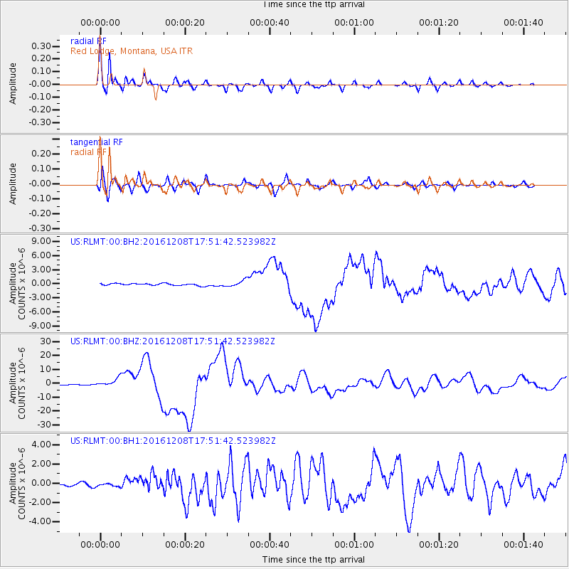
Signal To Noise
| Channel | StoN | STA | LTA |
| US:RLMT:00:BHZ:20161208T17:51:42.523982Z | 10.994985 | 2.9863447E-6 | 2.7160974E-7 |
| US:RLMT:00:BH1:20161208T17:51:42.523982Z | 1.0204833 | 1.8092652E-7 | 1.7729495E-7 |
| US:RLMT:00:BH2:20161208T17:51:42.523982Z | 3.3297162 | 7.20585E-7 | 2.1641034E-7 |
| Arrivals |
| Ps | 2.2 SECOND |
| PpPs | 7.2 SECOND |
| PsPs/PpSs | 9.4 SECOND |


