You are here: Home > Network List > US - United States National Seismic Network Stations List
> Station WRAK Wrangell Island, Southeastern Alaska, Alaska, USA > Earthquake Result Viewer
WRAK Wrangell Island, Southeastern Alaska, Alaska, USA - Earthquake Result Viewer
| Earthquake location: |
Solomon Islands |
| Earthquake latitude/longitude: |
-10.7/161.3 |
| Earthquake time(UTC): |
2016/12/08 (343) 17:38:46 GMT |
| Earthquake Depth: |
41 km |
| Earthquake Magnitude: |
7.8 mww |
| Earthquake Catalog/Contributor: |
NEIC PDE/us |
|
| Network: |
US United States National Seismic Network |
| Station: |
WRAK Wrangell Island, Southeastern Alaska, Alaska, USA |
| Lat/Lon: |
56.42 N/132.35 W |
| Elevation: |
81 m |
|
| Distance: |
86.2 deg |
| Az: |
30.667 deg |
| Baz: |
244.444 deg |
| Ray Param: |
0.0441619 |
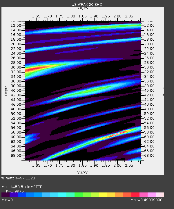
| Estimated Moho Depth: |
58.5 km |
| Estimated Crust Vp/Vs: |
2.00 |
| Assumed Crust Vp: |
6.597 km/s |
| Estimated Crust Vs: |
3.303 km/s |
| Estimated Crust Poisson's Ratio: |
0.33 |
|
| Radial Match: |
97.1123 % |
| Radial Bump: |
320 |
| Transverse Match: |
83.063644 % |
| Transverse Bump: |
400 |
| SOD ConfigId: |
1894071 |
| Insert Time: |
2016-12-22 17:41:58.349 +0000 |
| GWidth: |
2.5 |
| Max Bumps: |
400 |
| Tol: |
0.001 |
|
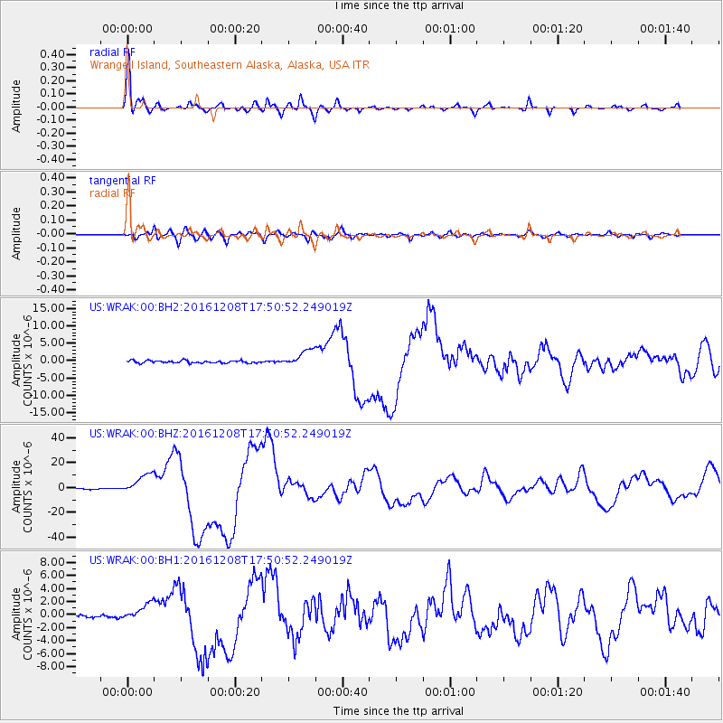
Signal To Noise
| Channel | StoN | STA | LTA |
| US:WRAK:00:BHZ:20161208T17:50:52.249019Z | 17.452644 | 8.420087E-6 | 4.824534E-7 |
| US:WRAK:00:BH1:20161208T17:50:52.249019Z | 5.548876 | 1.3336764E-6 | 2.4035074E-7 |
| US:WRAK:00:BH2:20161208T17:50:52.249019Z | 6.8357096 | 2.4165045E-6 | 3.5351184E-7 |
| Arrivals |
| Ps | 9.0 SECOND |
| PpPs | 26 SECOND |
| PsPs/PpSs | 35 SECOND |


