You are here: Home > Network List > TA - USArray Transportable Network (new EarthScope stations) Stations List
> Station F20K Avaraart Lake, AK, USA > Earthquake Result Viewer
F20K Avaraart Lake, AK, USA - Earthquake Result Viewer
| Earthquake location: |
Central California |
| Earthquake latitude/longitude: |
35.7/-117.5 |
| Earthquake time(UTC): |
2019/07/04 (185) 17:33:49 GMT |
| Earthquake Depth: |
11 km |
| Earthquake Magnitude: |
6.4 mw |
| Earthquake Catalog/Contributor: |
NEIC PDE/ci |
|
| Network: |
TA USArray Transportable Network (new EarthScope stations) |
| Station: |
F20K Avaraart Lake, AK, USA |
| Lat/Lon: |
67.05 N/155.73 W |
| Elevation: |
136 m |
|
| Distance: |
38.3 deg |
| Az: |
336.93 deg |
| Baz: |
125.589 deg |
| Ray Param: |
0.07566513 |
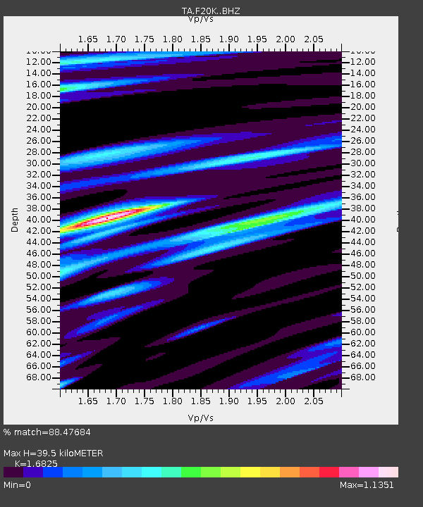
| Estimated Moho Depth: |
39.5 km |
| Estimated Crust Vp/Vs: |
1.68 |
| Assumed Crust Vp: |
6.522 km/s |
| Estimated Crust Vs: |
3.876 km/s |
| Estimated Crust Poisson's Ratio: |
0.23 |
|
| Radial Match: |
88.47684 % |
| Radial Bump: |
307 |
| Transverse Match: |
60.177757 % |
| Transverse Bump: |
400 |
| SOD ConfigId: |
19053131 |
| Insert Time: |
2019-07-18 17:38:15.123 +0000 |
| GWidth: |
2.5 |
| Max Bumps: |
400 |
| Tol: |
0.001 |
|

Signal To Noise
| Channel | StoN | STA | LTA |
| TA:F20K: :BHZ:20190704T17:40:38.325004Z | 1.2448708 | 9.281155E-8 | 7.455517E-8 |
| TA:F20K: :BHN:20190704T17:40:38.325004Z | 0.9233938 | 6.8252156E-8 | 7.3914464E-8 |
| TA:F20K: :BHE:20190704T17:40:38.325004Z | 1.1230892 | 7.714985E-8 | 6.869432E-8 |
| Arrivals |
| Ps | 4.5 SECOND |
| PpPs | 15 SECOND |
| PsPs/PpSs | 19 SECOND |


