You are here: Home > Network List > TA - USArray Transportable Network (new EarthScope stations) Stations List
> Station G31M Satah River, YT, CAN > Earthquake Result Viewer
G31M Satah River, YT, CAN - Earthquake Result Viewer

| Earthquake location: |
Central California |
| Earthquake latitude/longitude: |
35.7/-117.5 |
| Earthquake time(UTC): |
2019/07/04 (185) 17:33:49 GMT |
| Earthquake Depth: |
11 km |
| Earthquake Magnitude: |
6.4 mw |
| Earthquake Catalog/Contributor: |
NEIC PDE/ci |
|
| Network: |
TA USArray Transportable Network (new EarthScope stations) |
| Station: |
G31M Satah River, YT, CAN |
| Lat/Lon: |
66.92 N/134.27 W |
| Elevation: |
61 m |
|
| Distance: |
32.7 deg |
| Az: |
347.862 deg |
| Baz: |
154.27 deg |
| Ray Param: |
0.07852397 |
| Estimated Moho Depth: |
31.5 km |
| Estimated Crust Vp/Vs: |
1.91 |
| Assumed Crust Vp: |
6.171 km/s |
| Estimated Crust Vs: |
3.235 km/s |
| Estimated Crust Poisson's Ratio: |
0.31 |
|
| Radial Match: |
92.73234 % |
| Radial Bump: |
294 |
| Transverse Match: |
86.55955 % |
| Transverse Bump: |
400 |
| SOD ConfigId: |
19053131 |
| Insert Time: |
2019-07-18 17:38:19.241 +0000 |
| GWidth: |
2.5 |
| Max Bumps: |
400 |
| Tol: |
0.001 |
|
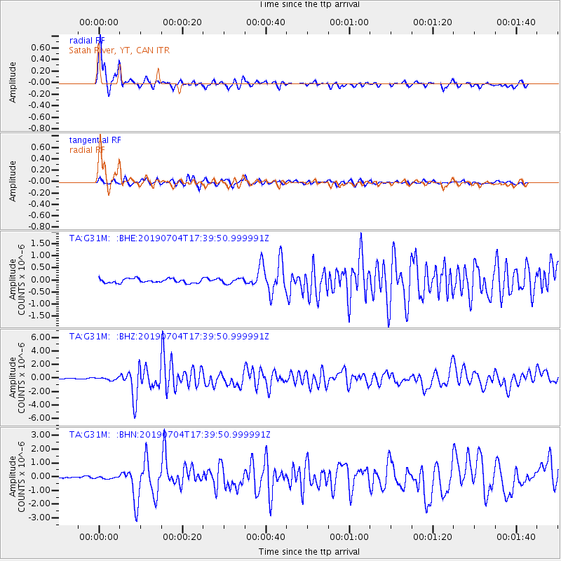
Signal To Noise
| Channel | StoN | STA | LTA |
| TA:G31M: :BHZ:20190704T17:39:50.999991Z | 2.1545854 | 1.8486976E-7 | 8.5802945E-8 |
| TA:G31M: :BHN:20190704T17:39:50.999991Z | 1.0556511 | 6.7637544E-8 | 6.407188E-8 |
| TA:G31M: :BHE:20190704T17:39:50.999991Z | 1.1916649 | 9.913498E-8 | 8.319031E-8 |
| Arrivals |
| Ps | 5.0 SECOND |
| PpPs | 14 SECOND |
| PsPs/PpSs | 19 SECOND |


