You are here: Home > Network List > TA - USArray Transportable Network (new EarthScope stations) Stations List
> Station J16K Anvik River, AK, USA > Earthquake Result Viewer
J16K Anvik River, AK, USA - Earthquake Result Viewer
| Earthquake location: |
Central California |
| Earthquake latitude/longitude: |
35.7/-117.5 |
| Earthquake time(UTC): |
2019/07/04 (185) 17:33:49 GMT |
| Earthquake Depth: |
11 km |
| Earthquake Magnitude: |
6.4 mw |
| Earthquake Catalog/Contributor: |
NEIC PDE/ci |
|
| Network: |
TA USArray Transportable Network (new EarthScope stations) |
| Station: |
J16K Anvik River, AK, USA |
| Lat/Lon: |
63.28 N/160.60 W |
| Elevation: |
328 m |
|
| Distance: |
38.1 deg |
| Az: |
329.971 deg |
| Baz: |
115.692 deg |
| Ray Param: |
0.075753815 |
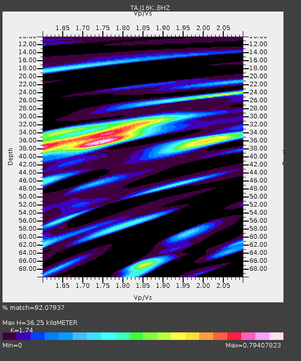
| Estimated Moho Depth: |
36.25 km |
| Estimated Crust Vp/Vs: |
1.74 |
| Assumed Crust Vp: |
6.276 km/s |
| Estimated Crust Vs: |
3.607 km/s |
| Estimated Crust Poisson's Ratio: |
0.25 |
|
| Radial Match: |
92.07937 % |
| Radial Bump: |
310 |
| Transverse Match: |
67.20667 % |
| Transverse Bump: |
400 |
| SOD ConfigId: |
19053131 |
| Insert Time: |
2019-07-18 17:38:24.265 +0000 |
| GWidth: |
2.5 |
| Max Bumps: |
400 |
| Tol: |
0.001 |
|

Signal To Noise
| Channel | StoN | STA | LTA |
| TA:J16K: :BHZ:20190704T17:40:37.05001Z | 2.190765 | 1.9574388E-7 | 8.9349555E-8 |
| TA:J16K: :BHN:20190704T17:40:37.05001Z | 1.2989575 | 9.379342E-8 | 7.220669E-8 |
| TA:J16K: :BHE:20190704T17:40:37.05001Z | 1.4081264 | 1.3527477E-7 | 9.606722E-8 |
| Arrivals |
| Ps | 4.6 SECOND |
| PpPs | 15 SECOND |
| PsPs/PpSs | 19 SECOND |


