You are here: Home > Network List > TA - USArray Transportable Network (new EarthScope stations) Stations List
> Station I30M Mount Dempster, Yukon, CAN > Earthquake Result Viewer
I30M Mount Dempster, Yukon, CAN - Earthquake Result Viewer
| Earthquake location: |
Central California |
| Earthquake latitude/longitude: |
35.7/-117.5 |
| Earthquake time(UTC): |
2019/07/04 (185) 17:33:49 GMT |
| Earthquake Depth: |
11 km |
| Earthquake Magnitude: |
6.4 mw |
| Earthquake Catalog/Contributor: |
NEIC PDE/ci |
|
| Network: |
TA USArray Transportable Network (new EarthScope stations) |
| Station: |
I30M Mount Dempster, Yukon, CAN |
| Lat/Lon: |
65.22 N/136.38 W |
| Elevation: |
1399 m |
|
| Distance: |
31.6 deg |
| Az: |
344.935 deg |
| Baz: |
149.87 deg |
| Ray Param: |
0.078994595 |
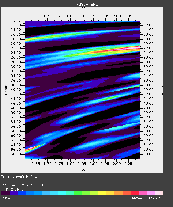
| Estimated Moho Depth: |
21.25 km |
| Estimated Crust Vp/Vs: |
2.10 |
| Assumed Crust Vp: |
6.566 km/s |
| Estimated Crust Vs: |
3.13 km/s |
| Estimated Crust Poisson's Ratio: |
0.35 |
|
| Radial Match: |
88.97441 % |
| Radial Bump: |
400 |
| Transverse Match: |
66.49035 % |
| Transverse Bump: |
400 |
| SOD ConfigId: |
19053131 |
| Insert Time: |
2019-07-18 17:38:24.767 +0000 |
| GWidth: |
2.5 |
| Max Bumps: |
400 |
| Tol: |
0.001 |
|
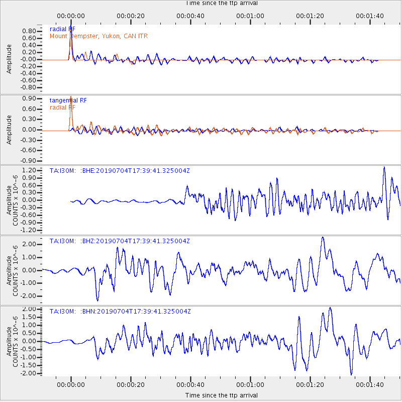
Signal To Noise
| Channel | StoN | STA | LTA |
| TA:I30M: :BHZ:20190704T17:39:41.325004Z | 1.8487797 | 1.889011E-7 | 1.02176095E-7 |
| TA:I30M: :BHN:20190704T17:39:41.325004Z | 2.1180584 | 9.268915E-8 | 4.376137E-8 |
| TA:I30M: :BHE:20190704T17:39:41.325004Z | 1.0283272 | 4.8266802E-8 | 4.6937203E-8 |
| Arrivals |
| Ps | 3.8 SECOND |
| PpPs | 9.3 SECOND |
| PsPs/PpSs | 13 SECOND |


