You are here: Home > Network List > TA - USArray Transportable Network (new EarthScope stations) Stations List
> Station M14K Bethel, AK, USA > Earthquake Result Viewer
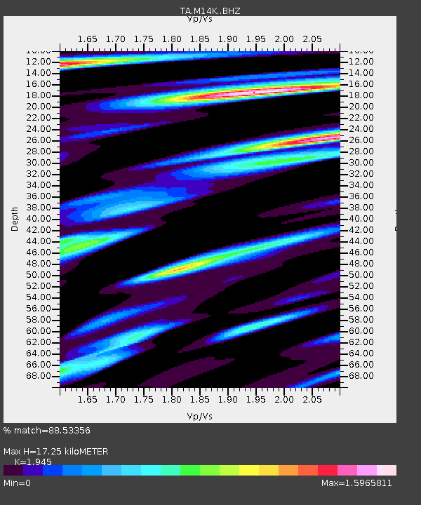
M14K Bethel, AK, USA - Earthquake Result Viewer
| Earthquake location: |
Central California |
| Earthquake latitude/longitude: |
35.7/-117.5 |
| Earthquake time(UTC): |
2019/07/04 (185) 17:33:49 GMT |
| Earthquake Depth: |
11 km |
| Earthquake Magnitude: |
6.4 mw |
| Earthquake Catalog/Contributor: |
NEIC PDE/ci |
|
| Network: |
TA USArray Transportable Network (new EarthScope stations) |
| Station: |
M14K Bethel, AK, USA |
| Lat/Lon: |
60.75 N/161.96 W |
| Elevation: |
19 m |
|
| Distance: |
37.7 deg |
| Az: |
325.758 deg |
| Baz: |
111.169 deg |
| Ray Param: |
0.0759997 |
| Estimated Moho Depth: |
17.25 km |
| Estimated Crust Vp/Vs: |
1.95 |
| Assumed Crust Vp: |
6.182 km/s |
| Estimated Crust Vs: |
3.179 km/s |
| Estimated Crust Poisson's Ratio: |
0.32 |
|
| Radial Match: |
88.53356 % |
| Radial Bump: |
400 |
| Transverse Match: |
72.9255 % |
| Transverse Bump: |
400 |
| SOD ConfigId: |
19053131 |
| Insert Time: |
2019-07-18 17:38:31.011 +0000 |
| GWidth: |
2.5 |
| Max Bumps: |
400 |
| Tol: |
0.001 |
|

Signal To Noise
| Channel | StoN | STA | LTA |
| TA:M14K: :BHZ:20190704T17:40:33.474998Z | 2.1605022 | 2.5162373E-7 | 1.16465394E-7 |
| TA:M14K: :BHN:20190704T17:40:33.474998Z | 1.5490465 | 2.3017043E-7 | 1.4858846E-7 |
| TA:M14K: :BHE:20190704T17:40:33.474998Z | 0.90340227 | 2.0815553E-7 | 2.304129E-7 |
| Arrivals |
| Ps | 2.8 SECOND |
| PpPs | 7.7 SECOND |
| PsPs/PpSs | 11 SECOND |


